You are here: Home > Network List > TA - USArray Transportable Network (new EarthScope stations) Stations List
> Station HAST UC Hastings Reserve, Carmel Valley, CA, USA > Earthquake Result Viewer
HAST UC Hastings Reserve, Carmel Valley, CA, USA - Earthquake Result Viewer

| Earthquake location: |
South Of Fiji Islands |
| Earthquake latitude/longitude: |
-23.6/-180.0 |
| Earthquake time(UTC): |
2006/02/26 (057) 03:08:27 GMT |
| Earthquake Depth: |
535 km |
| Earthquake Magnitude: |
5.9 MB, 6.4 MW, 6.4 MW |
| Earthquake Catalog/Contributor: |
WHDF/NEIC |
|
| Network: |
TA USArray Transportable Network (new EarthScope stations) |
| Station: |
HAST UC Hastings Reserve, Carmel Valley, CA, USA |
| Lat/Lon: |
36.39 N/121.55 W |
| Elevation: |
542 m |
|
| Distance: |
81.2 deg |
| Az: |
44.078 deg |
| Baz: |
232.261 deg |
| Ray Param: |
0.04613559 |
| Estimated Moho Depth: |
67.75 km |
| Estimated Crust Vp/Vs: |
1.65 |
| Assumed Crust Vp: |
6.391 km/s |
| Estimated Crust Vs: |
3.873 km/s |
| Estimated Crust Poisson's Ratio: |
0.21 |
|
| Radial Match: |
93.09062 % |
| Radial Bump: |
400 |
| Transverse Match: |
85.576805 % |
| Transverse Bump: |
400 |
| SOD ConfigId: |
2422 |
| Insert Time: |
2010-03-07 04:38:52.066 +0000 |
| GWidth: |
2.5 |
| Max Bumps: |
400 |
| Tol: |
0.001 |
|
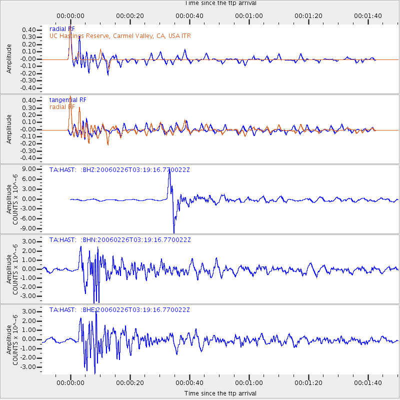
Signal To Noise
| Channel | StoN | STA | LTA |
| TA:HAST: :BHN:20060226T03:19:16.770022Z | 8.0954895 | 9.750328E-7 | 1.2044148E-7 |
| TA:HAST: :BHE:20060226T03:19:16.770022Z | 7.347439 | 1.0801494E-6 | 1.4701034E-7 |
| TA:HAST: :BHZ:20060226T03:19:16.770022Z | 22.791197 | 3.858234E-6 | 1.6928614E-7 |
| Arrivals |
| Ps | 7.1 SECOND |
| PpPs | 27 SECOND |
| PsPs/PpSs | 34 SECOND |


