You are here: Home > Network List > TA - USArray Transportable Network (new EarthScope stations) Stations List
> Station F20K Avaraart Lake, AK, USA > Earthquake Result Viewer
F20K Avaraart Lake, AK, USA - Earthquake Result Viewer
| Earthquake location: |
Turkey |
| Earthquake latitude/longitude: |
40.9/28.2 |
| Earthquake time(UTC): |
2019/09/26 (269) 10:59:26 GMT |
| Earthquake Depth: |
10 km |
| Earthquake Magnitude: |
5.7 Mww |
| Earthquake Catalog/Contributor: |
NEIC PDE/us |
|
| Network: |
TA USArray Transportable Network (new EarthScope stations) |
| Station: |
F20K Avaraart Lake, AK, USA |
| Lat/Lon: |
67.05 N/155.73 W |
| Elevation: |
136 m |
|
| Distance: |
72.3 deg |
| Az: |
1.603 deg |
| Baz: |
356.9 deg |
| Ray Param: |
0.0537194 |
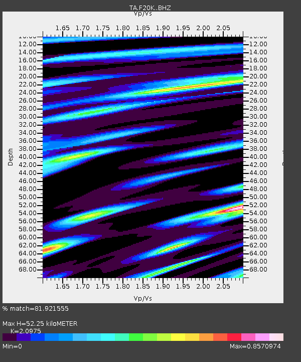
| Estimated Moho Depth: |
52.25 km |
| Estimated Crust Vp/Vs: |
2.10 |
| Assumed Crust Vp: |
6.522 km/s |
| Estimated Crust Vs: |
3.109 km/s |
| Estimated Crust Poisson's Ratio: |
0.35 |
|
| Radial Match: |
81.921555 % |
| Radial Bump: |
391 |
| Transverse Match: |
83.38335 % |
| Transverse Bump: |
400 |
| SOD ConfigId: |
19053131 |
| Insert Time: |
2019-10-10 11:08:42.402 +0000 |
| GWidth: |
2.5 |
| Max Bumps: |
400 |
| Tol: |
0.001 |
|

Signal To Noise
| Channel | StoN | STA | LTA |
| TA:F20K: :BHZ:20190926T11:10:20.825023Z | 7.184918 | 6.348173E-7 | 8.835415E-8 |
| TA:F20K: :BHN:20190926T11:10:20.825023Z | 3.1622 | 2.6441631E-7 | 8.3617834E-8 |
| TA:F20K: :BHE:20190926T11:10:20.825023Z | 1.6760727 | 1.18290096E-7 | 7.057576E-8 |
| Arrivals |
| Ps | 9.1 SECOND |
| PpPs | 24 SECOND |
| PsPs/PpSs | 33 SECOND |


