You are here: Home > Network List > TA - USArray Transportable Network (new EarthScope stations) Stations List
> Station HAST UC Hastings Reserve, Carmel Valley, CA, USA > Earthquake Result Viewer
HAST UC Hastings Reserve, Carmel Valley, CA, USA - Earthquake Result Viewer

| Earthquake location: |
Santiago Del Estero Prov., Arg. |
| Earthquake latitude/longitude: |
-28.6/-65.8 |
| Earthquake time(UTC): |
2004/09/07 (251) 11:53:06 GMT |
| Earthquake Depth: |
22 km |
| Earthquake Magnitude: |
6.1 MB, 6.1 MS, 6.4 MW, 6.2 MW |
| Earthquake Catalog/Contributor: |
WHDF/NEIC |
|
| Network: |
TA USArray Transportable Network (new EarthScope stations) |
| Station: |
HAST UC Hastings Reserve, Carmel Valley, CA, USA |
| Lat/Lon: |
36.39 N/121.55 W |
| Elevation: |
542 m |
|
| Distance: |
83.2 deg |
| Az: |
317.822 deg |
| Baz: |
132.956 deg |
| Ray Param: |
0.04635038 |
| Estimated Moho Depth: |
22.5 km |
| Estimated Crust Vp/Vs: |
1.83 |
| Assumed Crust Vp: |
6.391 km/s |
| Estimated Crust Vs: |
3.487 km/s |
| Estimated Crust Poisson's Ratio: |
0.29 |
|
| Radial Match: |
80.77047 % |
| Radial Bump: |
400 |
| Transverse Match: |
75.36895 % |
| Transverse Bump: |
400 |
| SOD ConfigId: |
2459 |
| Insert Time: |
2010-03-07 04:39:11.865 +0000 |
| GWidth: |
2.5 |
| Max Bumps: |
400 |
| Tol: |
0.001 |
|
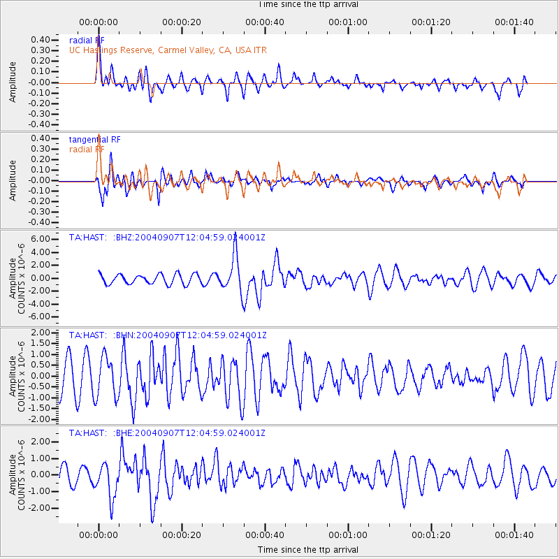
Signal To Noise
| Channel | StoN | STA | LTA |
| TA:HAST: :BHN:20040907T12:04:59.024001Z | 1.4884639 | 9.3567223E-7 | 6.28616E-7 |
| TA:HAST: :BHE:20040907T12:04:59.024001Z | 1.7847369 | 1.0545057E-6 | 5.908466E-7 |
| TA:HAST: :BHZ:20040907T12:04:59.024001Z | 3.8985338 | 2.9140635E-6 | 7.4747675E-7 |
| Arrivals |
| Ps | 3.0 SECOND |
| PpPs | 9.7 SECOND |
| PsPs/PpSs | 13 SECOND |


