You are here: Home > Network List > TA - USArray Transportable Network (new EarthScope stations) Stations List
> Station HAST UC Hastings Reserve, Carmel Valley, CA, USA > Earthquake Result Viewer
HAST UC Hastings Reserve, Carmel Valley, CA, USA - Earthquake Result Viewer
| Earthquake location: |
Near West Coast Of Colombia |
| Earthquake latitude/longitude: |
4.7/-77.5 |
| Earthquake time(UTC): |
2004/11/15 (320) 09:06:56 GMT |
| Earthquake Depth: |
15 km |
| Earthquake Magnitude: |
6.6 MB, 7.1 MS, 7.2 MW, 7.1 MW |
| Earthquake Catalog/Contributor: |
WHDF/NEIC |
|
| Network: |
TA USArray Transportable Network (new EarthScope stations) |
| Station: |
HAST UC Hastings Reserve, Carmel Valley, CA, USA |
| Lat/Lon: |
36.39 N/121.55 W |
| Elevation: |
542 m |
|
| Distance: |
51.2 deg |
| Az: |
313.992 deg |
| Baz: |
117.296 deg |
| Ray Param: |
0.06752865 |
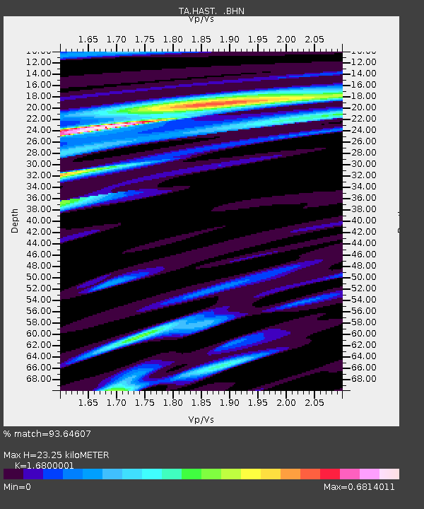
| Estimated Moho Depth: |
23.25 km |
| Estimated Crust Vp/Vs: |
1.68 |
| Assumed Crust Vp: |
6.391 km/s |
| Estimated Crust Vs: |
3.804 km/s |
| Estimated Crust Poisson's Ratio: |
0.23 |
|
| Radial Match: |
93.64607 % |
| Radial Bump: |
400 |
| Transverse Match: |
88.08072 % |
| Transverse Bump: |
400 |
| SOD ConfigId: |
2459 |
| Insert Time: |
2010-03-07 04:39:23.022 +0000 |
| GWidth: |
2.5 |
| Max Bumps: |
400 |
| Tol: |
0.001 |
|

Signal To Noise
| Channel | StoN | STA | LTA |
| TA:HAST: :BHN:20041115T09:15:28.470004Z | 4.115934 | 1.0917388E-6 | 2.652469E-7 |
| TA:HAST: :BHE:20041115T09:15:28.470004Z | 13.642648 | 2.6482528E-6 | 1.9411574E-7 |
| TA:HAST: :BHZ:20041115T09:15:28.470004Z | 16.277308 | 4.881281E-6 | 2.9988257E-7 |
| Arrivals |
| Ps | 2.6 SECOND |
| PpPs | 9.2 SECOND |
| PsPs/PpSs | 12 SECOND |


