You are here: Home > Network List > TA - USArray Transportable Network (new EarthScope stations) Stations List
> Station HAST UC Hastings Reserve, Carmel Valley, CA, USA > Earthquake Result Viewer
HAST UC Hastings Reserve, Carmel Valley, CA, USA - Earthquake Result Viewer

| Earthquake location: |
Jujuy Province, Argentina |
| Earthquake latitude/longitude: |
-22.2/-65.8 |
| Earthquake time(UTC): |
2007/07/21 (202) 15:34:52 GMT |
| Earthquake Depth: |
290 km |
| Earthquake Magnitude: |
5.8 MB, 6.4 MW, 6.3 MW |
| Earthquake Catalog/Contributor: |
WHDF/NEIC |
|
| Network: |
TA USArray Transportable Network (new EarthScope stations) |
| Station: |
HAST UC Hastings Reserve, Carmel Valley, CA, USA |
| Lat/Lon: |
36.39 N/121.55 W |
| Elevation: |
542 m |
|
| Distance: |
78.5 deg |
| Az: |
317.091 deg |
| Baz: |
128.535 deg |
| Ray Param: |
0.048823643 |
| Estimated Moho Depth: |
24.5 km |
| Estimated Crust Vp/Vs: |
1.67 |
| Assumed Crust Vp: |
6.391 km/s |
| Estimated Crust Vs: |
3.827 km/s |
| Estimated Crust Poisson's Ratio: |
0.22 |
|
| Radial Match: |
86.38702 % |
| Radial Bump: |
400 |
| Transverse Match: |
65.11379 % |
| Transverse Bump: |
400 |
| SOD ConfigId: |
2564 |
| Insert Time: |
2010-03-07 04:39:33.396 +0000 |
| GWidth: |
2.5 |
| Max Bumps: |
400 |
| Tol: |
0.001 |
|
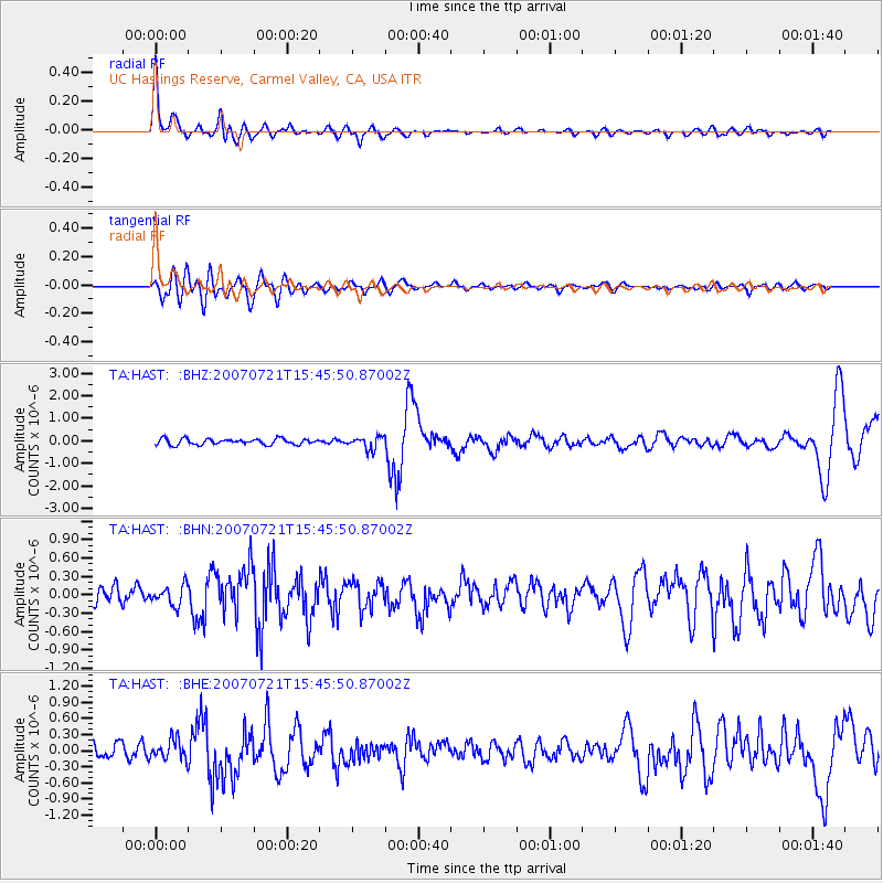
Signal To Noise
| Channel | StoN | STA | LTA |
| TA:HAST: :BHN:20070721T15:45:50.87002Z | 0.9201948 | 1.5808591E-7 | 1.7179613E-7 |
| TA:HAST: :BHE:20070721T15:45:50.87002Z | 1.4696485 | 1.891245E-7 | 1.286869E-7 |
| TA:HAST: :BHZ:20070721T15:45:50.87002Z | 2.1980178 | 2.8247973E-7 | 1.2851568E-7 |
| Arrivals |
| Ps | 2.6 SECOND |
| PpPs | 9.9 SECOND |
| PsPs/PpSs | 13 SECOND |


