You are here: Home > Network List > TA - USArray Transportable Network (new EarthScope stations) Stations List
> Station D10A Wagner Farm, Oakesdale, WA, USA > Earthquake Result Viewer
D10A Wagner Farm, Oakesdale, WA, USA - Earthquake Result Viewer
| Earthquake location: |
Northern Chile |
| Earthquake latitude/longitude: |
-22.2/-69.9 |
| Earthquake time(UTC): |
2007/11/14 (318) 15:40:50 GMT |
| Earthquake Depth: |
40 km |
| Earthquake Magnitude: |
6.7 MB, 7.4 MS, 7.7 MW, 7.4 ME |
| Earthquake Catalog/Contributor: |
WHDF/NEIC |
|
| Network: |
TA USArray Transportable Network (new EarthScope stations) |
| Station: |
D10A Wagner Farm, Oakesdale, WA, USA |
| Lat/Lon: |
47.05 N/117.28 W |
| Elevation: |
775 m |
|
| Distance: |
81.1 deg |
| Az: |
329.384 deg |
| Baz: |
136.366 deg |
| Ray Param: |
0.047740594 |
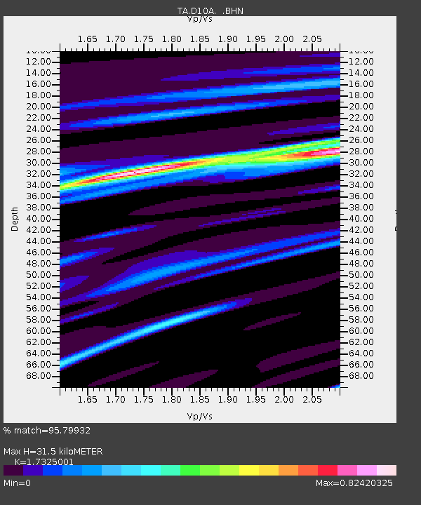
| Estimated Moho Depth: |
31.5 km |
| Estimated Crust Vp/Vs: |
1.73 |
| Assumed Crust Vp: |
6.571 km/s |
| Estimated Crust Vs: |
3.793 km/s |
| Estimated Crust Poisson's Ratio: |
0.25 |
|
| Radial Match: |
95.79932 % |
| Radial Bump: |
400 |
| Transverse Match: |
86.34555 % |
| Transverse Bump: |
400 |
| SOD ConfigId: |
2564 |
| Insert Time: |
2010-03-07 04:40:44.672 +0000 |
| GWidth: |
2.5 |
| Max Bumps: |
400 |
| Tol: |
0.001 |
|

Signal To Noise
| Channel | StoN | STA | LTA |
| TA:D10A: :BHN:20071114T15:52:30.67502Z | 6.0311966 | 1.1836253E-6 | 1.962505E-7 |
| TA:D10A: :BHE:20071114T15:52:30.67502Z | 8.19703 | 1.1999699E-6 | 1.463908E-7 |
| TA:D10A: :BHZ:20071114T15:52:30.67502Z | 25.053108 | 4.707006E-6 | 1.8788113E-7 |
| Arrivals |
| Ps | 3.6 SECOND |
| PpPs | 13 SECOND |
| PsPs/PpSs | 16 SECOND |


