You are here: Home > Network List > TA - USArray Transportable Network (new EarthScope stations) Stations List
> Station D10A Wagner Farm, Oakesdale, WA, USA > Earthquake Result Viewer
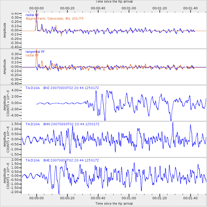
D10A Wagner Farm, Oakesdale, WA, USA - Earthquake Result Viewer

| Earthquake location: |
South Of Mariana Islands |
| Earthquake latitude/longitude: |
10.5/145.7 |
| Earthquake time(UTC): |
2007/09/30 (273) 02:08:30 GMT |
| Earthquake Depth: |
14 km |
| Earthquake Magnitude: |
6.4 MB, 7.1 MS, 6.9 MW, 6.9 MW |
| Earthquake Catalog/Contributor: |
WHDF/NEIC |
|
| Network: |
TA USArray Transportable Network (new EarthScope stations) |
| Station: |
D10A Wagner Farm, Oakesdale, WA, USA |
| Lat/Lon: |
47.05 N/117.28 W |
| Elevation: |
775 m |
|
| Distance: |
87.2 deg |
| Az: |
42.803 deg |
| Baz: |
282.185 deg |
| Ray Param: |
0.043515693 |
| Estimated Moho Depth: |
23.5 km |
| Estimated Crust Vp/Vs: |
1.97 |
| Assumed Crust Vp: |
6.571 km/s |
| Estimated Crust Vs: |
3.335 km/s |
| Estimated Crust Poisson's Ratio: |
0.33 |
|
| Radial Match: |
87.8491 % |
| Radial Bump: |
400 |
| Transverse Match: |
80.27004 % |
| Transverse Bump: |
400 |
| SOD ConfigId: |
2564 |
| Insert Time: |
2010-03-07 04:40:47.506 +0000 |
| GWidth: |
2.5 |
| Max Bumps: |
400 |
| Tol: |
0.001 |
|
Signal To Noise
| Channel | StoN | STA | LTA |
| TA:D10A: :BHN:20070930T02:20:44.125017Z | 1.0747012 | 1.6788825E-7 | 1.5621853E-7 |
| TA:D10A: :BHE:20070930T02:20:44.125017Z | 1.2908247 | 1.8954177E-7 | 1.4683772E-7 |
| TA:D10A: :BHZ:20070930T02:20:44.125017Z | 3.4719741 | 4.8388716E-7 | 1.3936948E-7 |
| Arrivals |
| Ps | 3.5 SECOND |
| PpPs | 10 SECOND |
| PsPs/PpSs | 14 SECOND |


