You are here: Home > Network List > TA - USArray Transportable Network (new EarthScope stations) Stations List
> Station D10A Wagner Farm, Oakesdale, WA, USA > Earthquake Result Viewer
D10A Wagner Farm, Oakesdale, WA, USA - Earthquake Result Viewer

| Earthquake location: |
Jujuy Province, Argentina |
| Earthquake latitude/longitude: |
-22.2/-65.8 |
| Earthquake time(UTC): |
2007/07/21 (202) 15:34:52 GMT |
| Earthquake Depth: |
290 km |
| Earthquake Magnitude: |
5.8 MB, 6.4 MW, 6.3 MW |
| Earthquake Catalog/Contributor: |
WHDF/NEIC |
|
| Network: |
TA USArray Transportable Network (new EarthScope stations) |
| Station: |
D10A Wagner Farm, Oakesdale, WA, USA |
| Lat/Lon: |
47.05 N/117.28 W |
| Elevation: |
775 m |
|
| Distance: |
83.0 deg |
| Az: |
327.38 deg |
| Baz: |
133.038 deg |
| Ray Param: |
0.04572157 |
| Estimated Moho Depth: |
33.5 km |
| Estimated Crust Vp/Vs: |
1.60 |
| Assumed Crust Vp: |
6.571 km/s |
| Estimated Crust Vs: |
4.107 km/s |
| Estimated Crust Poisson's Ratio: |
0.18 |
|
| Radial Match: |
86.696205 % |
| Radial Bump: |
400 |
| Transverse Match: |
73.113365 % |
| Transverse Bump: |
400 |
| SOD ConfigId: |
2564 |
| Insert Time: |
2010-03-07 04:41:02.083 +0000 |
| GWidth: |
2.5 |
| Max Bumps: |
400 |
| Tol: |
0.001 |
|
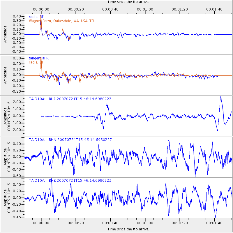
Signal To Noise
| Channel | StoN | STA | LTA |
| TA:D10A: :BHN:20070721T15:46:14.698022Z | 2.8834317 | 1.3159601E-7 | 4.563868E-8 |
| TA:D10A: :BHE:20070721T15:46:14.698022Z | 2.971555 | 1.2231477E-7 | 4.1161876E-8 |
| TA:D10A: :BHZ:20070721T15:46:14.698022Z | 5.239276 | 3.3204674E-7 | 6.3376454E-8 |
| Arrivals |
| Ps | 3.1 SECOND |
| PpPs | 13 SECOND |
| PsPs/PpSs | 16 SECOND |


