You are here: Home > Network List > WY - Yellowstone Wyoming Seismic Network Stations List
> Station YNR Norris Junction, YNP, WY, USA > Earthquake Result Viewer
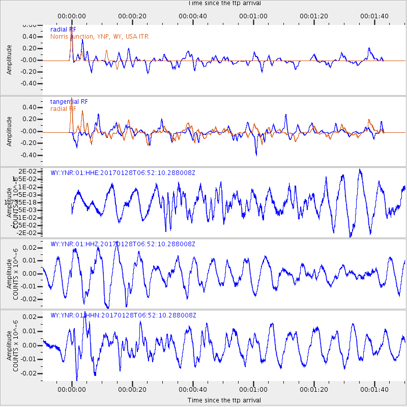
YNR Norris Junction, YNP, WY, USA - Earthquake Result Viewer
*The percent match for this event was below the threshold and hence no stack was calculated.
| Earthquake location: |
Near Coast Of Northern Peru |
| Earthquake latitude/longitude: |
-9.3/-78.9 |
| Earthquake time(UTC): |
2017/01/28 (028) 06:42:32 GMT |
| Earthquake Depth: |
46 km |
| Earthquake Magnitude: |
5.3 Mww |
| Earthquake Catalog/Contributor: |
NEIC PDE/us |
|
| Network: |
WY Yellowstone Wyoming Seismic Network |
| Station: |
YNR Norris Junction, YNP, WY, USA |
| Lat/Lon: |
44.72 N/110.68 W |
| Elevation: |
2336 m |
|
| Distance: |
61.0 deg |
| Az: |
334.554 deg |
| Baz: |
143.501 deg |
| Ray Param: |
$rayparam |
*The percent match for this event was below the threshold and hence was not used in the summary stack. |
|
| Radial Match: |
53.323284 % |
| Radial Bump: |
400 |
| Transverse Match: |
54.335503 % |
| Transverse Bump: |
400 |
| SOD ConfigId: |
1943534 |
| Insert Time: |
2017-02-11 06:47:59.039 +0000 |
| GWidth: |
2.5 |
| Max Bumps: |
400 |
| Tol: |
0.001 |
|
Signal To Noise
| Channel | StoN | STA | LTA |
| WY:YNR:01:HHZ:20170128T06:52:10.288008Z | 2.0220006 | 1.365947E-8 | 6.7554233E-9 |
| WY:YNR:01:HHN:20170128T06:52:10.288008Z | 2.479489 | 1.2683292E-8 | 5.115284E-9 |
| WY:YNR:01:HHE:20170128T06:52:10.288008Z | 1.1687906 | 7.2593926E-9 | 6.2110295E-9 |
| Arrivals |
| Ps | |
| PpPs | |
| PsPs/PpSs | |


