You are here: Home > Network List > TA - USArray Transportable Network (new EarthScope stations) Stations List
> Station D10A Wagner Farm, Oakesdale, WA, USA > Earthquake Result Viewer
D10A Wagner Farm, Oakesdale, WA, USA - Earthquake Result Viewer

| Earthquake location: |
Near West Coast Of Honshu, Japan |
| Earthquake latitude/longitude: |
37.3/136.6 |
| Earthquake time(UTC): |
2007/03/25 (084) 00:41:57 GMT |
| Earthquake Depth: |
8.0 km |
| Earthquake Magnitude: |
6.1 MB, 6.8 MS, 6.7 MW, 6.6 MW |
| Earthquake Catalog/Contributor: |
WHDF/NEIC |
|
| Network: |
TA USArray Transportable Network (new EarthScope stations) |
| Station: |
D10A Wagner Farm, Oakesdale, WA, USA |
| Lat/Lon: |
47.05 N/117.28 W |
| Elevation: |
775 m |
|
| Distance: |
73.2 deg |
| Az: |
43.325 deg |
| Baz: |
306.886 deg |
| Ray Param: |
0.053172015 |
| Estimated Moho Depth: |
30.25 km |
| Estimated Crust Vp/Vs: |
1.74 |
| Assumed Crust Vp: |
6.571 km/s |
| Estimated Crust Vs: |
3.771 km/s |
| Estimated Crust Poisson's Ratio: |
0.25 |
|
| Radial Match: |
87.36526 % |
| Radial Bump: |
400 |
| Transverse Match: |
77.74845 % |
| Transverse Bump: |
400 |
| SOD ConfigId: |
2564 |
| Insert Time: |
2010-03-07 04:41:15.617 +0000 |
| GWidth: |
2.5 |
| Max Bumps: |
400 |
| Tol: |
0.001 |
|
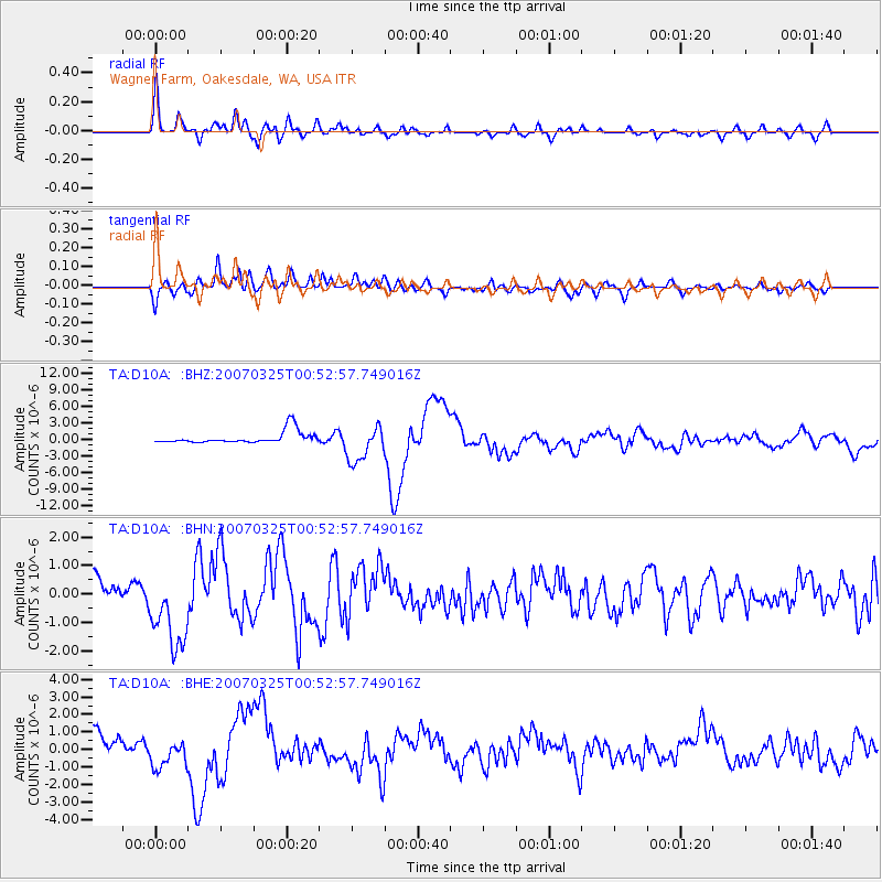
Signal To Noise
| Channel | StoN | STA | LTA |
| TA:D10A: :BHN:20070325T00:52:57.749016Z | 5.6477976 | 1.4157475E-6 | 2.506725E-7 |
| TA:D10A: :BHE:20070325T00:52:57.749016Z | 1.9559957 | 8.157034E-7 | 4.170272E-7 |
| TA:D10A: :BHZ:20070325T00:52:57.749016Z | 3.0259972 | 3.3121974E-6 | 1.0945805E-6 |
| Arrivals |
| Ps | 3.5 SECOND |
| PpPs | 12 SECOND |
| PsPs/PpSs | 16 SECOND |


