You are here: Home > Network List > TA - USArray Transportable Network (new EarthScope stations) Stations List
> Station HATC Hat Creek Radio Observatory, Hat Creek, CA, USA > Earthquake Result Viewer
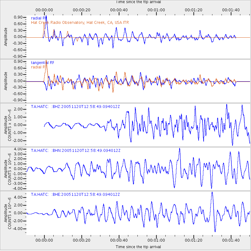
HATC Hat Creek Radio Observatory, Hat Creek, CA, USA - Earthquake Result Viewer
| Earthquake location: |
Unimak Island Region, Alaska |
| Earthquake latitude/longitude: |
53.8/-164.1 |
| Earthquake time(UTC): |
2005/11/20 (324) 12:53:02 GMT |
| Earthquake Depth: |
30 km |
| Earthquake Magnitude: |
5.7 MB, 5.8 MS, 6.2 MW, 6.0 MW |
| Earthquake Catalog/Contributor: |
WHDF/NEIC |
|
| Network: |
TA USArray Transportable Network (new EarthScope stations) |
| Station: |
HATC Hat Creek Radio Observatory, Hat Creek, CA, USA |
| Lat/Lon: |
40.82 N/121.46 W |
| Elevation: |
1013 m |
|
| Distance: |
31.2 deg |
| Az: |
97.092 deg |
| Baz: |
309.214 deg |
| Ray Param: |
0.07910567 |
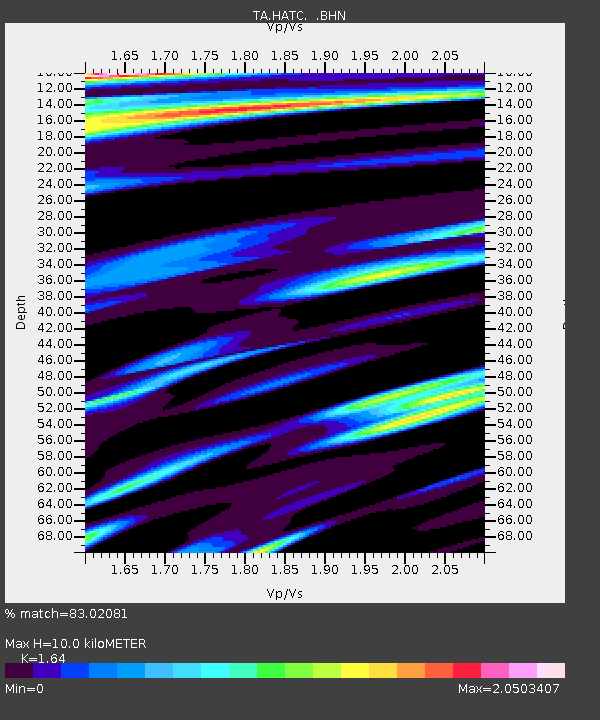
| Estimated Moho Depth: |
10.0 km |
| Estimated Crust Vp/Vs: |
1.64 |
| Assumed Crust Vp: |
6.566 km/s |
| Estimated Crust Vs: |
4.004 km/s |
| Estimated Crust Poisson's Ratio: |
0.20 |
|
| Radial Match: |
83.02081 % |
| Radial Bump: |
385 |
| Transverse Match: |
61.46717 % |
| Transverse Bump: |
400 |
| SOD ConfigId: |
132717 |
| Insert Time: |
2010-03-07 04:42:15.296 +0000 |
| GWidth: |
2.5 |
| Max Bumps: |
400 |
| Tol: |
0.001 |
|
Signal To Noise
| Channel | StoN | STA | LTA |
| TA:HATC: :BHN:20051120T12:58:49.094012Z | 1.223154 | 5.0227214E-7 | 4.106369E-7 |
| TA:HATC: :BHE:20051120T12:58:49.094012Z | 0.6612436 | 2.505013E-7 | 3.788336E-7 |
| TA:HATC: :BHZ:20051120T12:58:49.094012Z | 1.5679344 | 3.2559552E-7 | 2.076589E-7 |
| Arrivals |
| Ps | 1.1 SECOND |
| PpPs | 3.7 SECOND |
| PsPs/PpSs | 4.7 SECOND |


