You are here: Home > Network List > TA - USArray Transportable Network (new EarthScope stations) Stations List
> Station HATC Hat Creek Radio Observatory, Hat Creek, CA, USA > Earthquake Result Viewer
HATC Hat Creek Radio Observatory, Hat Creek, CA, USA - Earthquake Result Viewer
| Earthquake location: |
Rat Islands, Aleutian Islands |
| Earthquake latitude/longitude: |
51.2/179.4 |
| Earthquake time(UTC): |
2005/06/14 (165) 17:10:16 GMT |
| Earthquake Depth: |
51 km |
| Earthquake Magnitude: |
6.0 MB, 6.8 MW, 6.6 MW |
| Earthquake Catalog/Contributor: |
WHDF/NEIC |
|
| Network: |
TA USArray Transportable Network (new EarthScope stations) |
| Station: |
HATC Hat Creek Radio Observatory, Hat Creek, CA, USA |
| Lat/Lon: |
40.82 N/121.46 W |
| Elevation: |
1013 m |
|
| Distance: |
41.3 deg |
| Az: |
80.71 deg |
| Baz: |
305.163 deg |
| Ray Param: |
0.07373056 |
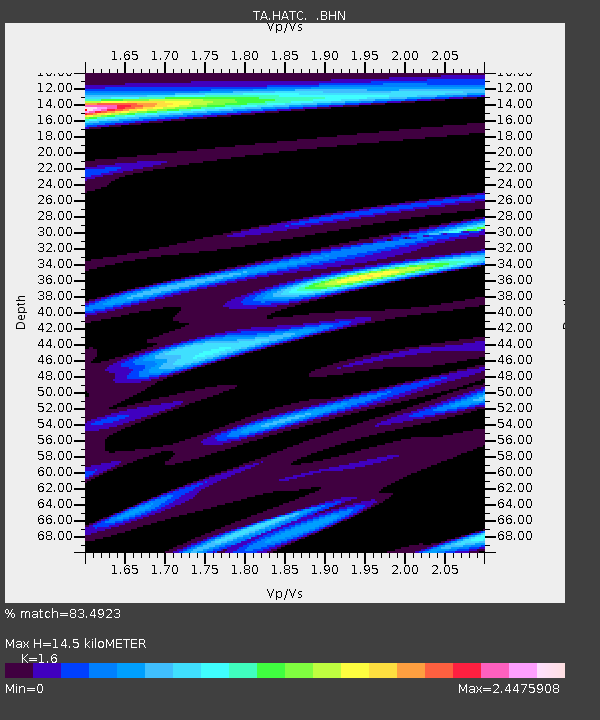
| Estimated Moho Depth: |
14.5 km |
| Estimated Crust Vp/Vs: |
1.60 |
| Assumed Crust Vp: |
6.566 km/s |
| Estimated Crust Vs: |
4.104 km/s |
| Estimated Crust Poisson's Ratio: |
0.18 |
|
| Radial Match: |
83.4923 % |
| Radial Bump: |
400 |
| Transverse Match: |
77.20535 % |
| Transverse Bump: |
400 |
| SOD ConfigId: |
144822 |
| Insert Time: |
2010-03-07 04:42:22.277 +0000 |
| GWidth: |
2.5 |
| Max Bumps: |
400 |
| Tol: |
0.001 |
|
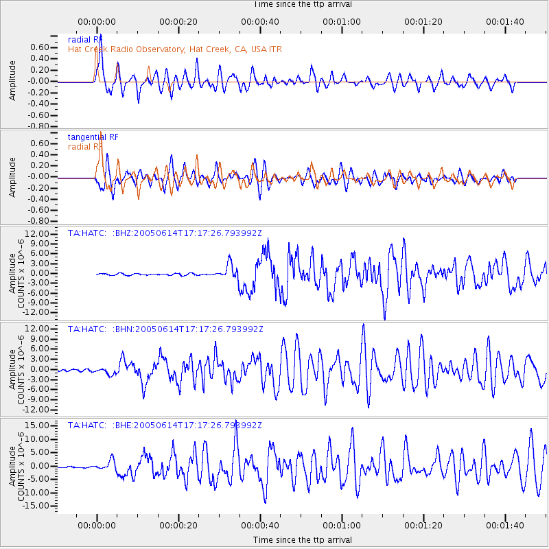
Signal To Noise
| Channel | StoN | STA | LTA |
| TA:HATC: :BHN:20050614T17:17:26.793992Z | 2.1288288 | 9.111355E-7 | 4.279985E-7 |
| TA:HATC: :BHE:20050614T17:17:26.793992Z | 4.982717 | 1.9413776E-6 | 3.8962227E-7 |
| TA:HATC: :BHZ:20050614T17:17:26.793992Z | 9.033332 | 2.458398E-6 | 2.7214745E-7 |
| Arrivals |
| Ps | 1.4 SECOND |
| PpPs | 5.3 SECOND |
| PsPs/PpSs | 6.7 SECOND |


