You are here: Home > Network List > TA - USArray Transportable Network (new EarthScope stations) Stations List
> Station HATC Hat Creek Radio Observatory, Hat Creek, CA, USA > Earthquake Result Viewer
HATC Hat Creek Radio Observatory, Hat Creek, CA, USA - Earthquake Result Viewer
| Earthquake location: |
Kuril Islands |
| Earthquake latitude/longitude: |
46.6/153.3 |
| Earthquake time(UTC): |
2006/11/15 (319) 11:14:13 GMT |
| Earthquake Depth: |
10 km |
| Earthquake Magnitude: |
6.5 MB, 7.8 MS, 8.3 MW, 7.9 MW |
| Earthquake Catalog/Contributor: |
WHDF/NEIC |
|
| Network: |
TA USArray Transportable Network (new EarthScope stations) |
| Station: |
HATC Hat Creek Radio Observatory, Hat Creek, CA, USA |
| Lat/Lon: |
40.82 N/121.46 W |
| Elevation: |
1013 m |
|
| Distance: |
59.0 deg |
| Az: |
61.909 deg |
| Baz: |
306.718 deg |
| Ray Param: |
0.062461276 |
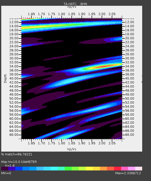
| Estimated Moho Depth: |
10.0 km |
| Estimated Crust Vp/Vs: |
1.60 |
| Assumed Crust Vp: |
6.566 km/s |
| Estimated Crust Vs: |
4.104 km/s |
| Estimated Crust Poisson's Ratio: |
0.18 |
|
| Radial Match: |
96.76221 % |
| Radial Bump: |
400 |
| Transverse Match: |
90.25722 % |
| Transverse Bump: |
400 |
| SOD ConfigId: |
2564 |
| Insert Time: |
2010-03-07 04:42:37.367 +0000 |
| GWidth: |
2.5 |
| Max Bumps: |
400 |
| Tol: |
0.001 |
|
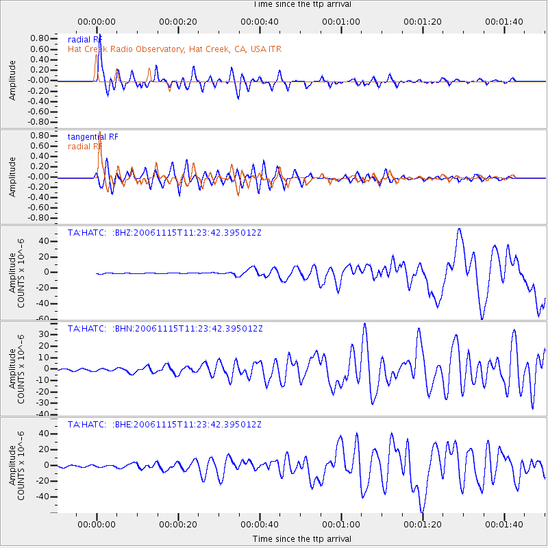
Signal To Noise
| Channel | StoN | STA | LTA |
| TA:HATC: :BHN:20061115T11:23:42.395012Z | 1.1555548 | 9.793102E-7 | 8.474806E-7 |
| TA:HATC: :BHE:20061115T11:23:42.395012Z | 1.0970482 | 1.0063776E-6 | 9.173504E-7 |
| TA:HATC: :BHZ:20061115T11:23:42.395012Z | 4.0028853 | 1.7709115E-6 | 4.4240878E-7 |
| Arrivals |
| Ps | 1.0 SECOND |
| PpPs | 3.7 SECOND |
| PsPs/PpSs | 4.7 SECOND |


