You are here: Home > Network List > TA - USArray Transportable Network (new EarthScope stations) Stations List
> Station HATC Hat Creek Radio Observatory, Hat Creek, CA, USA > Earthquake Result Viewer
HATC Hat Creek Radio Observatory, Hat Creek, CA, USA - Earthquake Result Viewer
| Earthquake location: |
Near Coast Of Peru |
| Earthquake latitude/longitude: |
-13.5/-76.7 |
| Earthquake time(UTC): |
2006/10/20 (293) 10:48:56 GMT |
| Earthquake Depth: |
23 km |
| Earthquake Magnitude: |
5.9 MB, 6.6 MS, 6.7 MW, 6.6 MW |
| Earthquake Catalog/Contributor: |
WHDF/NEIC |
|
| Network: |
TA USArray Transportable Network (new EarthScope stations) |
| Station: |
HATC Hat Creek Radio Observatory, Hat Creek, CA, USA |
| Lat/Lon: |
40.82 N/121.46 W |
| Elevation: |
1013 m |
|
| Distance: |
68.1 deg |
| Az: |
324.804 deg |
| Baz: |
132.369 deg |
| Ray Param: |
0.05651933 |
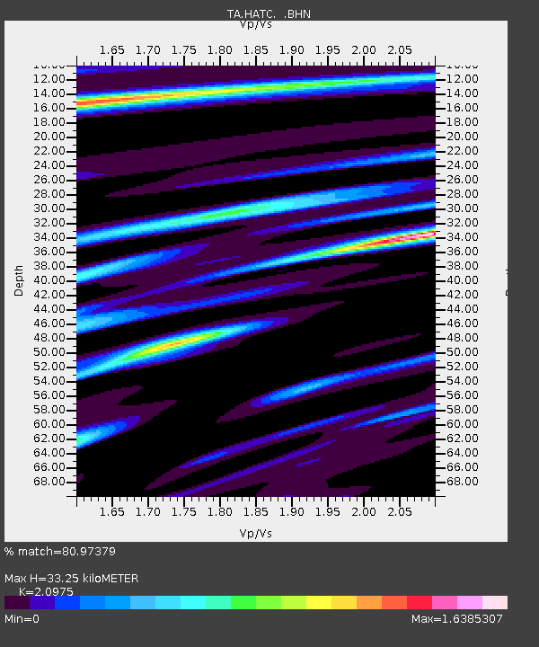
| Estimated Moho Depth: |
33.25 km |
| Estimated Crust Vp/Vs: |
2.10 |
| Assumed Crust Vp: |
6.566 km/s |
| Estimated Crust Vs: |
3.13 km/s |
| Estimated Crust Poisson's Ratio: |
0.35 |
|
| Radial Match: |
80.97379 % |
| Radial Bump: |
400 |
| Transverse Match: |
81.212585 % |
| Transverse Bump: |
400 |
| SOD ConfigId: |
2665 |
| Insert Time: |
2010-03-07 04:42:40.651 +0000 |
| GWidth: |
2.5 |
| Max Bumps: |
400 |
| Tol: |
0.001 |
|
Signal To Noise
| Channel | StoN | STA | LTA |
| TA:HATC: :BHN:20061020T10:59:22.569021Z | 0.6521717 | 3.508492E-7 | 5.3797066E-7 |
| TA:HATC: :BHE:20061020T10:59:22.569021Z | 1.3421344 | 6.5569884E-7 | 4.8854935E-7 |
| TA:HATC: :BHZ:20061020T10:59:22.569021Z | 6.5727677 | 1.0817784E-6 | 1.645849E-7 |
| Arrivals |
| Ps | 5.8 SECOND |
| PpPs | 15 SECOND |
| PsPs/PpSs | 21 SECOND |


