You are here: Home > Network List > UU - University of Utah Regional Network Stations List
> Station HMU Henry Mountain, UT, USA > Earthquake Result Viewer
HMU Henry Mountain, UT, USA - Earthquake Result Viewer
| Earthquake location: |
Central Chile |
| Earthquake latitude/longitude: |
-40.8/-72.2 |
| Earthquake time(UTC): |
2019/09/26 (269) 16:36:18 GMT |
| Earthquake Depth: |
130 km |
| Earthquake Magnitude: |
6.1 Mww |
| Earthquake Catalog/Contributor: |
NEIC PDE/us |
|
| Network: |
UU University of Utah Regional Network |
| Station: |
HMU Henry Mountain, UT, USA |
| Lat/Lon: |
37.94 N/110.74 W |
| Elevation: |
2430 m |
|
| Distance: |
85.9 deg |
| Az: |
330.369 deg |
| Baz: |
151.66 deg |
| Ray Param: |
0.044117957 |
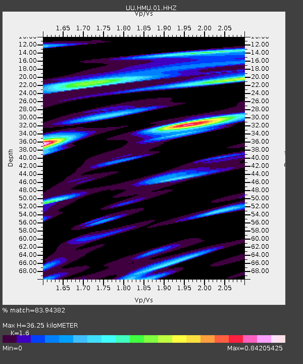
| Estimated Moho Depth: |
36.25 km |
| Estimated Crust Vp/Vs: |
1.60 |
| Assumed Crust Vp: |
6.247 km/s |
| Estimated Crust Vs: |
3.904 km/s |
| Estimated Crust Poisson's Ratio: |
0.18 |
|
| Radial Match: |
83.94382 % |
| Radial Bump: |
400 |
| Transverse Match: |
63.778824 % |
| Transverse Bump: |
400 |
| SOD ConfigId: |
19053131 |
| Insert Time: |
2019-10-10 16:48:15.669 +0000 |
| GWidth: |
2.5 |
| Max Bumps: |
400 |
| Tol: |
0.001 |
|

Signal To Noise
| Channel | StoN | STA | LTA |
| UU:HMU:01:HHZ:20190926T16:48:12.438015Z | 7.8534436 | 3.408796E-8 | 4.3405115E-9 |
| UU:HMU:01:HHN:20190926T16:48:12.438015Z | 3.4839683 | 1.1451297E-8 | 3.2868543E-9 |
| UU:HMU:01:HHE:20190926T16:48:12.438015Z | 2.6675012 | 1.1083712E-8 | 4.1550914E-9 |
| Arrivals |
| Ps | 3.6 SECOND |
| PpPs | 15 SECOND |
| PsPs/PpSs | 18 SECOND |


