You are here: Home > Network List > TA - USArray Transportable Network (new EarthScope stations) Stations List
> Station HATC Hat Creek Radio Observatory, Hat Creek, CA, USA > Earthquake Result Viewer
HATC Hat Creek Radio Observatory, Hat Creek, CA, USA - Earthquake Result Viewer
| Earthquake location: |
Kuril Islands |
| Earthquake latitude/longitude: |
45.8/150.1 |
| Earthquake time(UTC): |
2007/09/03 (246) 16:14:53 GMT |
| Earthquake Depth: |
94 km |
| Earthquake Magnitude: |
6.3 MB, 6.2 MW, 6.2 ME |
| Earthquake Catalog/Contributor: |
WHDF/NEIC |
|
| Network: |
TA USArray Transportable Network (new EarthScope stations) |
| Station: |
HATC Hat Creek Radio Observatory, Hat Creek, CA, USA |
| Lat/Lon: |
40.82 N/121.46 W |
| Elevation: |
1013 m |
|
| Distance: |
61.3 deg |
| Az: |
59.844 deg |
| Baz: |
307.206 deg |
| Ray Param: |
0.06068522 |
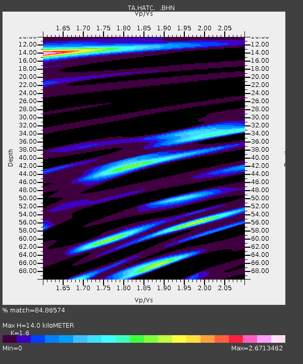
| Estimated Moho Depth: |
14.0 km |
| Estimated Crust Vp/Vs: |
1.60 |
| Assumed Crust Vp: |
6.566 km/s |
| Estimated Crust Vs: |
4.104 km/s |
| Estimated Crust Poisson's Ratio: |
0.18 |
|
| Radial Match: |
84.86574 % |
| Radial Bump: |
400 |
| Transverse Match: |
83.56879 % |
| Transverse Bump: |
400 |
| SOD ConfigId: |
2564 |
| Insert Time: |
2010-03-07 04:42:59.136 +0000 |
| GWidth: |
2.5 |
| Max Bumps: |
400 |
| Tol: |
0.001 |
|
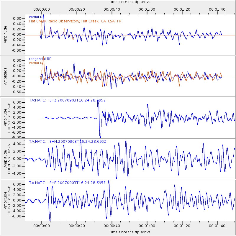
Signal To Noise
| Channel | StoN | STA | LTA |
| TA:HATC: :BHN:20070903T16:24:28.695Z | 2.955766 | 1.087296E-6 | 3.6785596E-7 |
| TA:HATC: :BHE:20070903T16:24:28.695Z | 7.753473 | 2.871248E-6 | 3.7031768E-7 |
| TA:HATC: :BHZ:20070903T16:24:28.695Z | 21.577856 | 3.9436413E-6 | 1.8276336E-7 |
| Arrivals |
| Ps | 1.3 SECOND |
| PpPs | 5.3 SECOND |
| PsPs/PpSs | 6.6 SECOND |


