You are here: Home > Network List > US - United States National Seismic Network Stations List
> Station EGMT Eagleton, Montana, USA > Earthquake Result Viewer
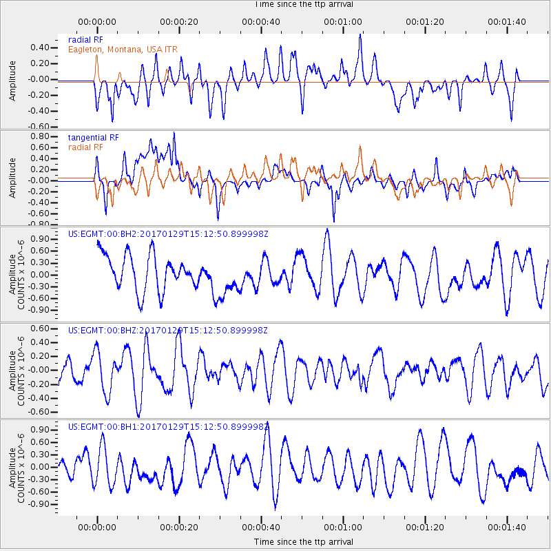
EGMT Eagleton, Montana, USA - Earthquake Result Viewer
*The percent match for this event was below the threshold and hence no stack was calculated.
| Earthquake location: |
Kermadec Islands Region |
| Earthquake latitude/longitude: |
-30.3/-176.7 |
| Earthquake time(UTC): |
2017/01/29 (029) 14:59:45 GMT |
| Earthquake Depth: |
10 km |
| Earthquake Magnitude: |
5.8 Mwb |
| Earthquake Catalog/Contributor: |
NEIC PDE/us |
|
| Network: |
US United States National Seismic Network |
| Station: |
EGMT Eagleton, Montana, USA |
| Lat/Lon: |
48.02 N/109.75 W |
| Elevation: |
1055 m |
|
| Distance: |
98.3 deg |
| Az: |
38.624 deg |
| Baz: |
233.552 deg |
| Ray Param: |
$rayparam |
*The percent match for this event was below the threshold and hence was not used in the summary stack. |
|
| Radial Match: |
41.026802 % |
| Radial Bump: |
400 |
| Transverse Match: |
58.747387 % |
| Transverse Bump: |
400 |
| SOD ConfigId: |
1943534 |
| Insert Time: |
2017-02-12 15:01:27.026 +0000 |
| GWidth: |
2.5 |
| Max Bumps: |
400 |
| Tol: |
0.001 |
|
Signal To Noise
| Channel | StoN | STA | LTA |
| US:EGMT:00:BHZ:20170129T15:12:50.899998Z | 1.5134368 | 2.9712865E-7 | 1.963271E-7 |
| US:EGMT:00:BH1:20170129T15:12:50.899998Z | 3.1774268 | 4.8110337E-7 | 1.5141288E-7 |
| US:EGMT:00:BH2:20170129T15:12:50.899998Z | 1.2348802 | 5.4868894E-7 | 4.4432565E-7 |
| Arrivals |
| Ps | |
| PpPs | |
| PsPs/PpSs | |


