You are here: Home > Network List > US - United States National Seismic Network Stations List
> Station MSO Missoula, Montana, USA > Earthquake Result Viewer
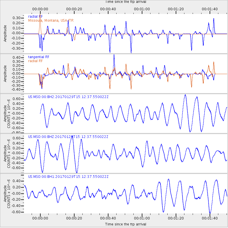
MSO Missoula, Montana, USA - Earthquake Result Viewer
*The percent match for this event was below the threshold and hence no stack was calculated.
| Earthquake location: |
Kermadec Islands Region |
| Earthquake latitude/longitude: |
-30.3/-176.7 |
| Earthquake time(UTC): |
2017/01/29 (029) 14:59:45 GMT |
| Earthquake Depth: |
10 km |
| Earthquake Magnitude: |
5.8 Mwb |
| Earthquake Catalog/Contributor: |
NEIC PDE/us |
|
| Network: |
US United States National Seismic Network |
| Station: |
MSO Missoula, Montana, USA |
| Lat/Lon: |
46.83 N/113.94 W |
| Elevation: |
1264 m |
|
| Distance: |
95.3 deg |
| Az: |
37.813 deg |
| Baz: |
230.575 deg |
| Ray Param: |
$rayparam |
*The percent match for this event was below the threshold and hence was not used in the summary stack. |
|
| Radial Match: |
53.54755 % |
| Radial Bump: |
330 |
| Transverse Match: |
50.934982 % |
| Transverse Bump: |
263 |
| SOD ConfigId: |
1943534 |
| Insert Time: |
2017-02-12 15:01:32.851 +0000 |
| GWidth: |
2.5 |
| Max Bumps: |
400 |
| Tol: |
0.001 |
|
Signal To Noise
| Channel | StoN | STA | LTA |
| US:MSO:00:BHZ:20170129T15:12:37.550022Z | 2.0735328 | 4.5280535E-7 | 2.1837384E-7 |
| US:MSO:00:BH1:20170129T15:12:37.550022Z | 0.23503117 | 7.8235885E-8 | 3.3287452E-7 |
| US:MSO:00:BH2:20170129T15:12:37.550022Z | 1.0491099 | 2.4018095E-7 | 2.2893782E-7 |
| Arrivals |
| Ps | |
| PpPs | |
| PsPs/PpSs | |


