You are here: Home > Network List > TA - USArray Transportable Network (new EarthScope stations) Stations List
> Station HATC Hat Creek Radio Observatory, Hat Creek, CA, USA > Earthquake Result Viewer
HATC Hat Creek Radio Observatory, Hat Creek, CA, USA - Earthquake Result Viewer
| Earthquake location: |
Solomon Islands |
| Earthquake latitude/longitude: |
-8.5/157.0 |
| Earthquake time(UTC): |
2007/04/01 (091) 20:39:56 GMT |
| Earthquake Depth: |
10 km |
| Earthquake Magnitude: |
6.8 MB, 7.9 MS, 8.1 MW, 7.7 ME |
| Earthquake Catalog/Contributor: |
WHDF/NEIC |
|
| Network: |
TA USArray Transportable Network (new EarthScope stations) |
| Station: |
HATC Hat Creek Radio Observatory, Hat Creek, CA, USA |
| Lat/Lon: |
40.82 N/121.46 W |
| Elevation: |
1013 m |
|
| Distance: |
89.1 deg |
| Az: |
48.653 deg |
| Baz: |
258.099 deg |
| Ray Param: |
0.04210383 |
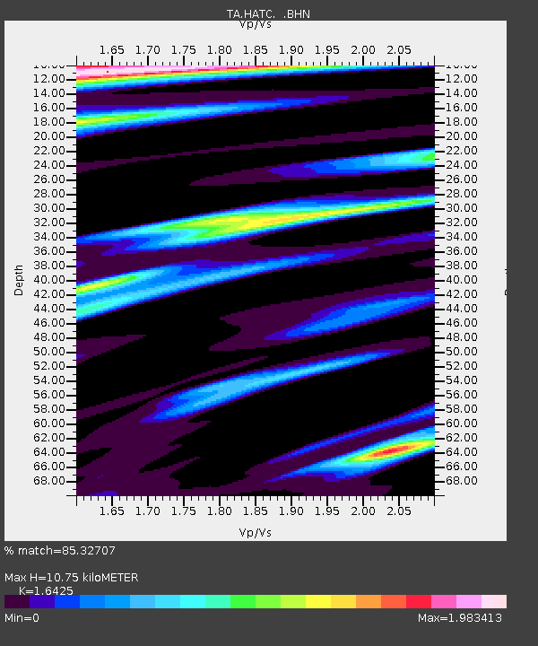
| Estimated Moho Depth: |
10.75 km |
| Estimated Crust Vp/Vs: |
1.64 |
| Assumed Crust Vp: |
6.566 km/s |
| Estimated Crust Vs: |
3.998 km/s |
| Estimated Crust Poisson's Ratio: |
0.21 |
|
| Radial Match: |
85.32707 % |
| Radial Bump: |
400 |
| Transverse Match: |
78.33703 % |
| Transverse Bump: |
400 |
| SOD ConfigId: |
2564 |
| Insert Time: |
2010-03-07 04:43:24.570 +0000 |
| GWidth: |
2.5 |
| Max Bumps: |
400 |
| Tol: |
0.001 |
|
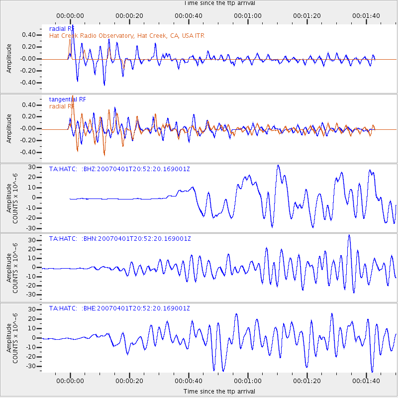
Signal To Noise
| Channel | StoN | STA | LTA |
| TA:HATC: :BHN:20070401T20:52:20.169001Z | 0.7322945 | 2.7302667E-7 | 3.7283726E-7 |
| TA:HATC: :BHE:20070401T20:52:20.169001Z | 2.0246363 | 7.9786884E-7 | 3.9408008E-7 |
| TA:HATC: :BHZ:20070401T20:52:20.169001Z | 8.447752 | 1.7642132E-6 | 2.0883817E-7 |
| Arrivals |
| Ps | 1.1 SECOND |
| PpPs | 4.2 SECOND |
| PsPs/PpSs | 5.3 SECOND |


