You are here: Home > Network List > TA - USArray Transportable Network (new EarthScope stations) Stations List
> Station L05A Lakeview, OR, USA > Earthquake Result Viewer
L05A Lakeview, OR, USA - Earthquake Result Viewer
| Earthquake location: |
Santa Cruz Islands |
| Earthquake latitude/longitude: |
-11.6/165.8 |
| Earthquake time(UTC): |
2007/09/02 (245) 01:05:18 GMT |
| Earthquake Depth: |
35 km |
| Earthquake Magnitude: |
5.9 MB, 7.3 MS, 7.2 MW, 6.9 ME |
| Earthquake Catalog/Contributor: |
WHDF/NEIC |
|
| Network: |
TA USArray Transportable Network (new EarthScope stations) |
| Station: |
L05A Lakeview, OR, USA |
| Lat/Lon: |
42.05 N/120.83 W |
| Elevation: |
1751 m |
|
| Distance: |
85.7 deg |
| Az: |
45.71 deg |
| Baz: |
250.329 deg |
| Ray Param: |
0.04453109 |
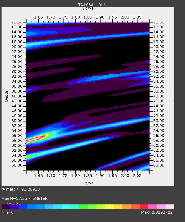
| Estimated Moho Depth: |
57.25 km |
| Estimated Crust Vp/Vs: |
1.63 |
| Assumed Crust Vp: |
6.597 km/s |
| Estimated Crust Vs: |
4.048 km/s |
| Estimated Crust Poisson's Ratio: |
0.20 |
|
| Radial Match: |
92.20928 % |
| Radial Bump: |
400 |
| Transverse Match: |
75.61108 % |
| Transverse Bump: |
400 |
| SOD ConfigId: |
2564 |
| Insert Time: |
2010-03-07 04:43:35.857 +0000 |
| GWidth: |
2.5 |
| Max Bumps: |
400 |
| Tol: |
0.001 |
|

Signal To Noise
| Channel | StoN | STA | LTA |
| TA:L05A: :BHN:20070902T01:17:22.248022Z | 2.7681181 | 5.052724E-7 | 1.8253282E-7 |
| TA:L05A: :BHE:20070902T01:17:22.248022Z | 5.1396585 | 1.2240528E-6 | 2.3815839E-7 |
| TA:L05A: :BHZ:20070902T01:17:22.248022Z | 17.719437 | 2.8652798E-6 | 1.6170264E-7 |
| Arrivals |
| Ps | 5.6 SECOND |
| PpPs | 22 SECOND |
| PsPs/PpSs | 28 SECOND |


