You are here: Home > Network List > TA - USArray Transportable Network (new EarthScope stations) Stations List
> Station L05A Lakeview, OR, USA > Earthquake Result Viewer
L05A Lakeview, OR, USA - Earthquake Result Viewer
| Earthquake location: |
Samoa Islands Region |
| Earthquake latitude/longitude: |
-16.6/-172.0 |
| Earthquake time(UTC): |
2006/09/28 (271) 06:22:09 GMT |
| Earthquake Depth: |
28 km |
| Earthquake Magnitude: |
6.5 MB, 6.6 MS, 6.9 MW, 6.7 MW |
| Earthquake Catalog/Contributor: |
WHDF/NEIC |
|
| Network: |
TA USArray Transportable Network (new EarthScope stations) |
| Station: |
L05A Lakeview, OR, USA |
| Lat/Lon: |
42.05 N/120.83 W |
| Elevation: |
1751 m |
|
| Distance: |
75.0 deg |
| Az: |
36.93 deg |
| Baz: |
230.67 deg |
| Ray Param: |
0.051896427 |
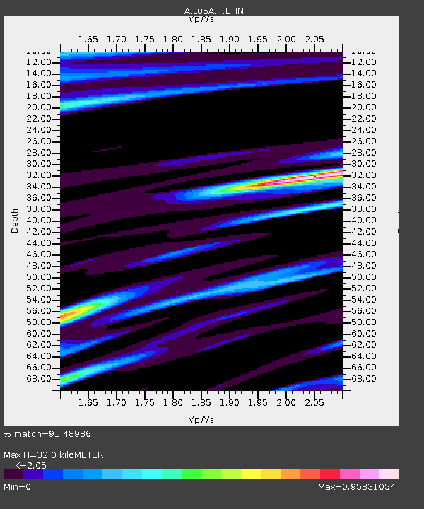
| Estimated Moho Depth: |
32.0 km |
| Estimated Crust Vp/Vs: |
2.05 |
| Assumed Crust Vp: |
6.597 km/s |
| Estimated Crust Vs: |
3.218 km/s |
| Estimated Crust Poisson's Ratio: |
0.34 |
|
| Radial Match: |
91.48986 % |
| Radial Bump: |
400 |
| Transverse Match: |
88.02426 % |
| Transverse Bump: |
400 |
| SOD ConfigId: |
2665 |
| Insert Time: |
2010-03-07 04:43:42.826 +0000 |
| GWidth: |
2.5 |
| Max Bumps: |
400 |
| Tol: |
0.001 |
|

Signal To Noise
| Channel | StoN | STA | LTA |
| TA:L05A: :BHN:20060928T06:33:17.599019Z | 7.1257377 | 1.6517353E-6 | 2.317985E-7 |
| TA:L05A: :BHE:20060928T06:33:17.599019Z | 8.172275 | 1.5211288E-6 | 1.8613285E-7 |
| TA:L05A: :BHZ:20060928T06:33:17.599019Z | 47.442047 | 6.3325933E-6 | 1.3348061E-7 |
| Arrivals |
| Ps | 5.2 SECOND |
| PpPs | 14 SECOND |
| PsPs/PpSs | 20 SECOND |


