You are here: Home > Network List > TA - USArray Transportable Network (new EarthScope stations) Stations List
> Station L05A Lakeview, OR, USA > Earthquake Result Viewer
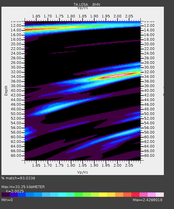
L05A Lakeview, OR, USA - Earthquake Result Viewer
| Earthquake location: |
Chile-Argentina Border Region |
| Earthquake latitude/longitude: |
-24.4/-67.0 |
| Earthquake time(UTC): |
2006/08/25 (237) 00:44:46 GMT |
| Earthquake Depth: |
184 km |
| Earthquake Magnitude: |
5.9 MB, 6.6 MW, 6.6 MW |
| Earthquake Catalog/Contributor: |
WHDF/NEIC |
|
| Network: |
TA USArray Transportable Network (new EarthScope stations) |
| Station: |
L05A Lakeview, OR, USA |
| Lat/Lon: |
42.05 N/120.83 W |
| Elevation: |
1751 m |
|
| Distance: |
82.7 deg |
| Az: |
322.701 deg |
| Baz: |
132.12 deg |
| Ray Param: |
0.04625532 |
| Estimated Moho Depth: |
33.25 km |
| Estimated Crust Vp/Vs: |
2.00 |
| Assumed Crust Vp: |
6.597 km/s |
| Estimated Crust Vs: |
3.295 km/s |
| Estimated Crust Poisson's Ratio: |
0.33 |
|
| Radial Match: |
93.0336 % |
| Radial Bump: |
400 |
| Transverse Match: |
79.696365 % |
| Transverse Bump: |
400 |
| SOD ConfigId: |
2665 |
| Insert Time: |
2010-03-07 04:43:45.778 +0000 |
| GWidth: |
2.5 |
| Max Bumps: |
400 |
| Tol: |
0.001 |
|

Signal To Noise
| Channel | StoN | STA | LTA |
| TA:L05A: :BHN:20060825T00:56:18.049019Z | 4.5371466 | 8.6339355E-7 | 1.902944E-7 |
| TA:L05A: :BHE:20060825T00:56:18.049019Z | 3.3903332 | 7.839297E-7 | 2.3122497E-7 |
| TA:L05A: :BHZ:20060825T00:56:18.049019Z | 26.238134 | 2.8610534E-6 | 1.0904179E-7 |
| Arrivals |
| Ps | 5.2 SECOND |
| PpPs | 15 SECOND |
| PsPs/PpSs | 20 SECOND |


