You are here: Home > Network List > TA - USArray Transportable Network (new EarthScope stations) Stations List
> Station L05A Lakeview, OR, USA > Earthquake Result Viewer
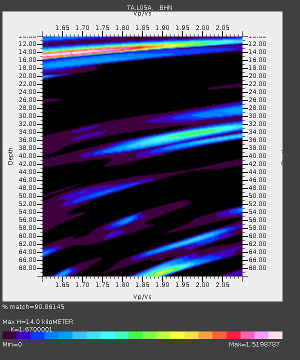
L05A Lakeview, OR, USA - Earthquake Result Viewer
| Earthquake location: |
Near East Coast Of Kamchatka |
| Earthquake latitude/longitude: |
51.1/157.5 |
| Earthquake time(UTC): |
2006/08/24 (236) 21:50:36 GMT |
| Earthquake Depth: |
43 km |
| Earthquake Magnitude: |
5.9 MB, 6.2 MS, 6.5 MW, 6.5 MW |
| Earthquake Catalog/Contributor: |
WHDF/NEIC |
|
| Network: |
TA USArray Transportable Network (new EarthScope stations) |
| Station: |
L05A Lakeview, OR, USA |
| Lat/Lon: |
42.05 N/120.83 W |
| Elevation: |
1751 m |
|
| Distance: |
54.1 deg |
| Az: |
65.475 deg |
| Baz: |
309.703 deg |
| Ray Param: |
0.06557027 |
| Estimated Moho Depth: |
14.0 km |
| Estimated Crust Vp/Vs: |
1.67 |
| Assumed Crust Vp: |
6.597 km/s |
| Estimated Crust Vs: |
3.951 km/s |
| Estimated Crust Poisson's Ratio: |
0.22 |
|
| Radial Match: |
90.86145 % |
| Radial Bump: |
400 |
| Transverse Match: |
85.42125 % |
| Transverse Bump: |
400 |
| SOD ConfigId: |
2665 |
| Insert Time: |
2010-03-07 04:43:47.525 +0000 |
| GWidth: |
2.5 |
| Max Bumps: |
400 |
| Tol: |
0.001 |
|

Signal To Noise
| Channel | StoN | STA | LTA |
| TA:L05A: :BHN:20060824T21:59:26.475012Z | 5.6380367 | 1.2504123E-6 | 2.2178152E-7 |
| TA:L05A: :BHE:20060824T21:59:26.475012Z | 5.793097 | 1.3419638E-6 | 2.3164877E-7 |
| TA:L05A: :BHZ:20060824T21:59:26.475012Z | 41.379467 | 5.052608E-6 | 1.2210423E-7 |
| Arrivals |
| Ps | 1.5 SECOND |
| PpPs | 5.3 SECOND |
| PsPs/PpSs | 6.8 SECOND |


