You are here: Home > Network List > TA - USArray Transportable Network (new EarthScope stations) Stations List
> Station L05A Lakeview, OR, USA > Earthquake Result Viewer
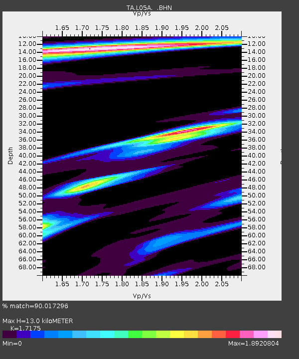
L05A Lakeview, OR, USA - Earthquake Result Viewer
| Earthquake location: |
Jujuy Province, Argentina |
| Earthquake latitude/longitude: |
-22.2/-65.8 |
| Earthquake time(UTC): |
2007/07/21 (202) 15:34:52 GMT |
| Earthquake Depth: |
290 km |
| Earthquake Magnitude: |
5.8 MB, 6.4 MW, 6.3 MW |
| Earthquake Catalog/Contributor: |
WHDF/NEIC |
|
| Network: |
TA USArray Transportable Network (new EarthScope stations) |
| Station: |
L05A Lakeview, OR, USA |
| Lat/Lon: |
42.05 N/120.83 W |
| Elevation: |
1751 m |
|
| Distance: |
81.6 deg |
| Az: |
321.895 deg |
| Baz: |
129.817 deg |
| Ray Param: |
0.046692863 |
| Estimated Moho Depth: |
13.0 km |
| Estimated Crust Vp/Vs: |
1.72 |
| Assumed Crust Vp: |
6.597 km/s |
| Estimated Crust Vs: |
3.841 km/s |
| Estimated Crust Poisson's Ratio: |
0.24 |
|
| Radial Match: |
90.017296 % |
| Radial Bump: |
338 |
| Transverse Match: |
71.60459 % |
| Transverse Bump: |
400 |
| SOD ConfigId: |
2564 |
| Insert Time: |
2010-03-07 04:44:06.019 +0000 |
| GWidth: |
2.5 |
| Max Bumps: |
400 |
| Tol: |
0.001 |
|

Signal To Noise
| Channel | StoN | STA | LTA |
| TA:L05A: :BHN:20070721T15:46:07.500024Z | 0.955879 | 2.4134945E-7 | 2.5248954E-7 |
| TA:L05A: :BHE:20070721T15:46:07.500024Z | 1.1620744 | 2.1598883E-7 | 1.8586489E-7 |
| TA:L05A: :BHZ:20070721T15:46:07.500024Z | 7.9867673 | 5.357428E-7 | 6.70788E-8 |
| Arrivals |
| Ps | 1.5 SECOND |
| PpPs | 5.2 SECOND |
| PsPs/PpSs | 6.7 SECOND |


