You are here: Home > Network List > G - GEOSCOPE Stations List
> Station WUS Wushi, Xinjiang Uygur, China > Earthquake Result Viewer
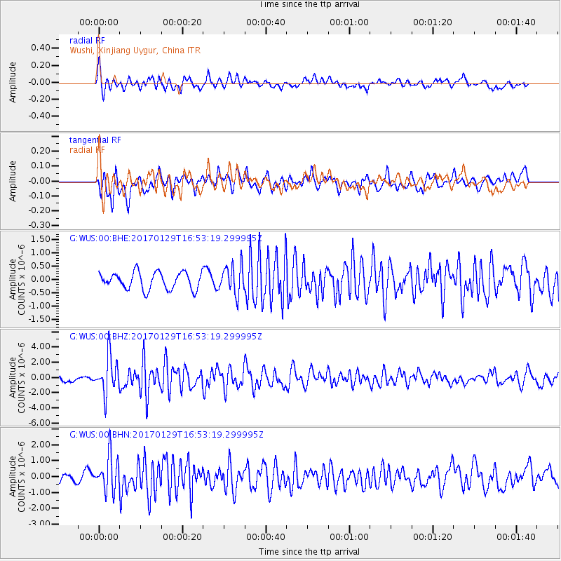
WUS Wushi, Xinjiang Uygur, China - Earthquake Result Viewer
*The percent match for this event was below the threshold and hence no stack was calculated.
| Earthquake location: |
Southwest Indian Ridge |
| Earthquake latitude/longitude: |
-29.2/61.1 |
| Earthquake time(UTC): |
2017/01/29 (029) 16:42:26 GMT |
| Earthquake Depth: |
10 km |
| Earthquake Magnitude: |
5.8 mb |
| Earthquake Catalog/Contributor: |
NEIC PDE/us |
|
| Network: |
G GEOSCOPE |
| Station: |
WUS Wushi, Xinjiang Uygur, China |
| Lat/Lon: |
41.20 N/79.22 E |
| Elevation: |
1457 m |
|
| Distance: |
72.0 deg |
| Az: |
14.253 deg |
| Baz: |
196.57 deg |
| Ray Param: |
$rayparam |
*The percent match for this event was below the threshold and hence was not used in the summary stack. |
|
| Radial Match: |
66.41825 % |
| Radial Bump: |
400 |
| Transverse Match: |
66.77513 % |
| Transverse Bump: |
400 |
| SOD ConfigId: |
1943534 |
| Insert Time: |
2017-02-12 16:43:06.517 +0000 |
| GWidth: |
2.5 |
| Max Bumps: |
400 |
| Tol: |
0.001 |
|
Signal To Noise
| Channel | StoN | STA | LTA |
| G:WUS:00:BHZ:20170129T16:53:19.299995Z | 6.7599945 | 2.4948683E-6 | 3.6906366E-7 |
| G:WUS:00:BHN:20170129T16:53:19.299995Z | 4.2102504 | 1.1616131E-6 | 2.7590121E-7 |
| G:WUS:00:BHE:20170129T16:53:19.299995Z | 1.7267001 | 5.5630574E-7 | 3.2217855E-7 |
| Arrivals |
| Ps | |
| PpPs | |
| PsPs/PpSs | |


