You are here: Home > Network List > TA - USArray Transportable Network (new EarthScope stations) Stations List
> Station M13A Montello, NV, USA > Earthquake Result Viewer
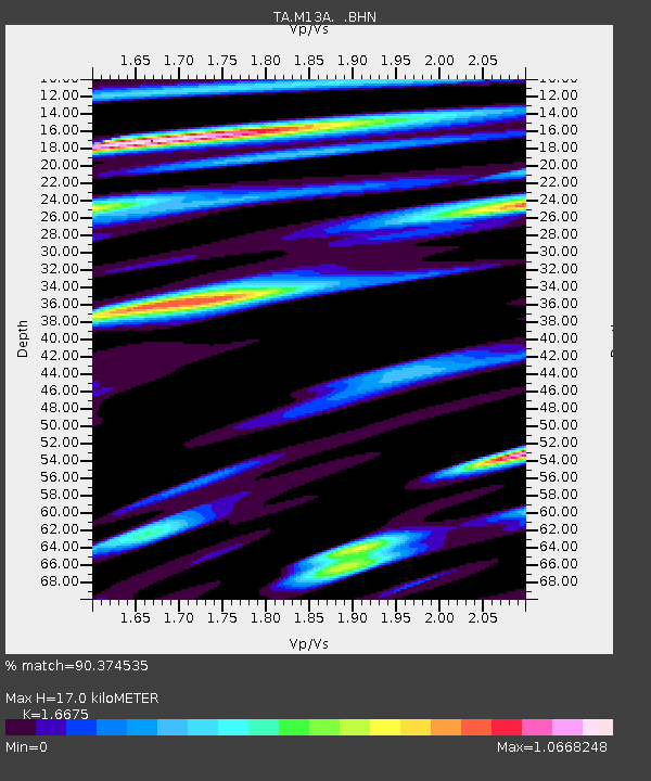
M13A Montello, NV, USA - Earthquake Result Viewer
| Earthquake location: |
Kuril Islands |
| Earthquake latitude/longitude: |
51.0/157.6 |
| Earthquake time(UTC): |
2008/07/24 (206) 01:43:16 GMT |
| Earthquake Depth: |
27 km |
| Earthquake Magnitude: |
6.0 MB, 6.0 MS, 6.2 MW, 6.2 MW |
| Earthquake Catalog/Contributor: |
WHDF/NEIC |
|
| Network: |
TA USArray Transportable Network (new EarthScope stations) |
| Station: |
M13A Montello, NV, USA |
| Lat/Lon: |
41.36 N/114.17 W |
| Elevation: |
1514 m |
|
| Distance: |
58.4 deg |
| Az: |
62.096 deg |
| Baz: |
312.07 deg |
| Ray Param: |
0.06285074 |
| Estimated Moho Depth: |
17.0 km |
| Estimated Crust Vp/Vs: |
1.67 |
| Assumed Crust Vp: |
6.276 km/s |
| Estimated Crust Vs: |
3.764 km/s |
| Estimated Crust Poisson's Ratio: |
0.22 |
|
| Radial Match: |
90.374535 % |
| Radial Bump: |
400 |
| Transverse Match: |
78.91728 % |
| Transverse Bump: |
400 |
| SOD ConfigId: |
2504 |
| Insert Time: |
2010-03-07 04:44:29.005 +0000 |
| GWidth: |
2.5 |
| Max Bumps: |
400 |
| Tol: |
0.001 |
|

Signal To Noise
| Channel | StoN | STA | LTA |
| TA:M13A: :BHN:20080724T01:52:38.048997Z | 16.087166 | 1.1066807E-6 | 6.8792765E-8 |
| TA:M13A: :BHE:20080724T01:52:38.048997Z | 4.376412 | 2.6774597E-7 | 6.1179335E-8 |
| TA:M13A: :BHZ:20080724T01:52:38.048997Z | 6.603171 | 4.194535E-7 | 6.3523046E-8 |
| Arrivals |
| Ps | 1.9 SECOND |
| PpPs | 6.9 SECOND |
| PsPs/PpSs | 8.8 SECOND |


