You are here: Home > Network List > TA - USArray Transportable Network (new EarthScope stations) Stations List
> Station M13A Montello, NV, USA > Earthquake Result Viewer
M13A Montello, NV, USA - Earthquake Result Viewer
| Earthquake location: |
Andreanof Islands, Aleutian Is. |
| Earthquake latitude/longitude: |
51.2/-179.0 |
| Earthquake time(UTC): |
2007/12/21 (355) 07:23:35 GMT |
| Earthquake Depth: |
30 km |
| Earthquake Magnitude: |
5.7 MB, 5.5 ML |
| Earthquake Catalog/Contributor: |
WHDF/NEIC |
|
| Network: |
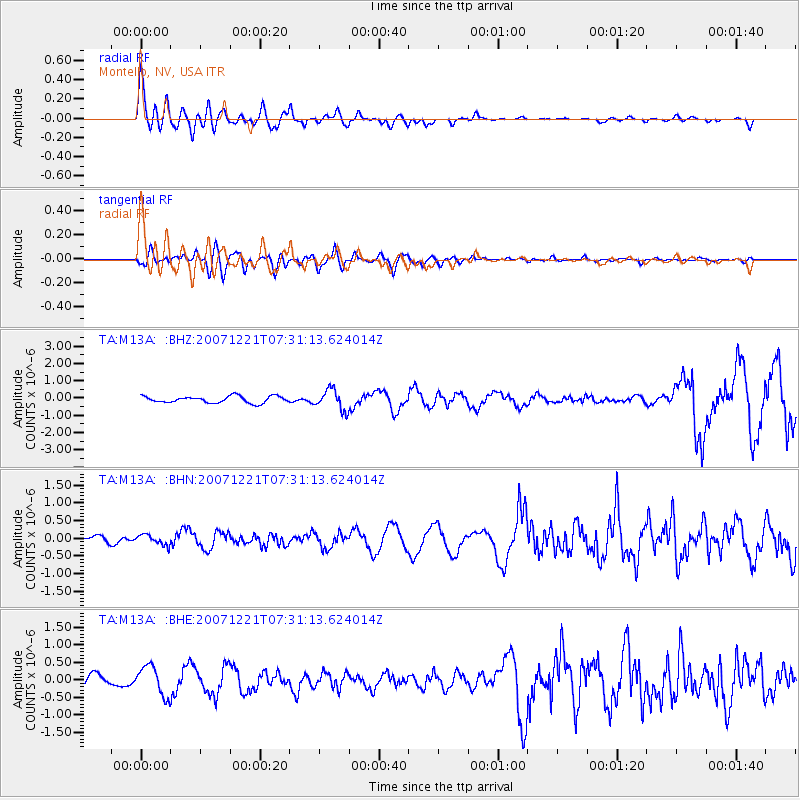
TA USArray Transportable Network (new EarthScope stations) |
| Station: |
M13A Montello, NV, USA |
| Lat/Lon: |
41.36 N/114.17 W |
| Elevation: |
1514 m |
|
| Distance: |
44.5 deg |
| Az: |
76.396 deg |
| Baz: |
305.75 deg |
| Ray Param: |
0.071817175 |
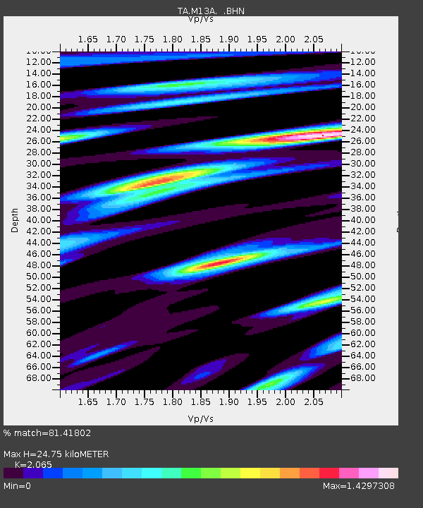
| Estimated Moho Depth: |
24.75 km |
| Estimated Crust Vp/Vs: |
2.07 |
| Assumed Crust Vp: |
6.276 km/s |
| Estimated Crust Vs: |
3.039 km/s |
| Estimated Crust Poisson's Ratio: |
0.35 |
|
| Radial Match: |
81.41802 % |
| Radial Bump: |
400 |
| Transverse Match: |
38.33113 % |
| Transverse Bump: |
400 |
| SOD ConfigId: |
2564 |
| Insert Time: |
2010-03-07 04:44:33.585 +0000 |
| GWidth: |
2.5 |
| Max Bumps: |
400 |
| Tol: |
0.001 |
|
Signal To Noise
| Channel | StoN | STA | LTA |
| TA:M13A: :BHN:20071221T07:31:13.624014Z | 1.0517285 | 1.4479214E-7 | 1.3767064E-7 |
| TA:M13A: :BHE:20071221T07:31:13.624014Z | 1.4023805 | 4.1866093E-7 | 2.985359E-7 |
| TA:M13A: :BHZ:20071221T07:31:13.624014Z | 3.056985 | 5.8947853E-7 | 1.9283003E-7 |
| Arrivals |
| Ps | 4.4 SECOND |
| PpPs | 11 SECOND |
| PsPs/PpSs | 16 SECOND |


