You are here: Home > Network List > II - Global Seismograph Network (GSN - IRIS/IDA) Stations List
> Station WRAB Tennant Creek, NT, Australia > Earthquake Result Viewer
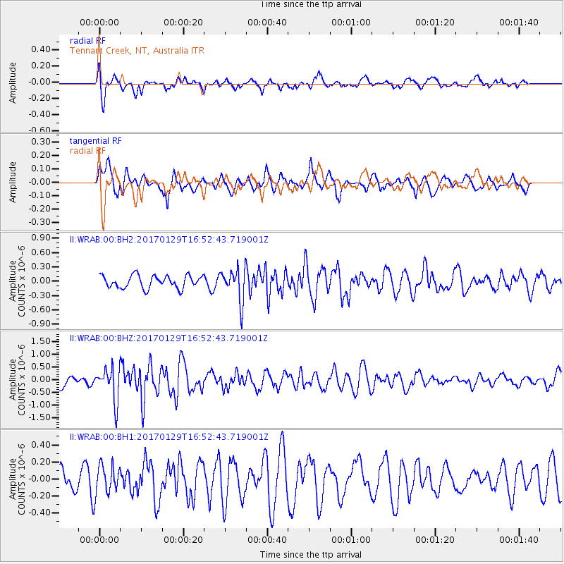
WRAB Tennant Creek, NT, Australia - Earthquake Result Viewer
*The percent match for this event was below the threshold and hence no stack was calculated.
| Earthquake location: |
Southwest Indian Ridge |
| Earthquake latitude/longitude: |
-29.2/61.1 |
| Earthquake time(UTC): |
2017/01/29 (029) 16:42:26 GMT |
| Earthquake Depth: |
10 km |
| Earthquake Magnitude: |
5.8 mb |
| Earthquake Catalog/Contributor: |
NEIC PDE/us |
|
| Network: |
II Global Seismograph Network (GSN - IRIS/IDA) |
| Station: |
WRAB Tennant Creek, NT, Australia |
| Lat/Lon: |
19.93 S/134.36 E |
| Elevation: |
366 m |
|
| Distance: |
66.3 deg |
| Az: |
100.337 deg |
| Baz: |
246.058 deg |
| Ray Param: |
$rayparam |
*The percent match for this event was below the threshold and hence was not used in the summary stack. |
|
| Radial Match: |
72.14259 % |
| Radial Bump: |
400 |
| Transverse Match: |
62.688793 % |
| Transverse Bump: |
400 |
| SOD ConfigId: |
1943534 |
| Insert Time: |
2017-02-12 16:43:31.107 +0000 |
| GWidth: |
2.5 |
| Max Bumps: |
400 |
| Tol: |
0.001 |
|
Signal To Noise
| Channel | StoN | STA | LTA |
| II:WRAB:00:BHZ:20170129T16:52:43.719001Z | 3.4084294 | 6.718656E-7 | 1.9711884E-7 |
| II:WRAB:00:BH1:20170129T16:52:43.719001Z | 0.79917485 | 1.5318847E-7 | 1.916833E-7 |
| II:WRAB:00:BH2:20170129T16:52:43.719001Z | 2.6560898 | 3.4838277E-7 | 1.3116379E-7 |
| Arrivals |
| Ps | |
| PpPs | |
| PsPs/PpSs | |


