You are here: Home > Network List > TS - TERRAscope (Southern California Seismic Network) Stations List
> Station NEE Needles, California, USA > Earthquake Result Viewer
NEE Needles, California, USA - Earthquake Result Viewer

| Earthquake location: |
Kermadec Islands Region |
| Earthquake latitude/longitude: |
-29.4/-176.7 |
| Earthquake time(UTC): |
1993/06/18 (169) 11:52:51 GMT |
| Earthquake Depth: |
21 km |
| Earthquake Magnitude: |
6.2 MB, 6.8 MS, 6.9 UNKNOWN, 6.8 MW |
| Earthquake Catalog/Contributor: |
WHDF/NEIC |
|
| Network: |
TS TERRAscope (Southern California Seismic Network) |
| Station: |
NEE Needles, California, USA |
| Lat/Lon: |
34.82 N/114.60 W |
| Elevation: |
139 m |
|
| Distance: |
86.7 deg |
| Az: |
46.77 deg |
| Baz: |
230.613 deg |
| Ray Param: |
0.04385513 |
| Estimated Moho Depth: |
31.5 km |
| Estimated Crust Vp/Vs: |
1.72 |
| Assumed Crust Vp: |
6.276 km/s |
| Estimated Crust Vs: |
3.649 km/s |
| Estimated Crust Poisson's Ratio: |
0.24 |
|
| Radial Match: |
80.88476 % |
| Radial Bump: |
400 |
| Transverse Match: |
73.91588 % |
| Transverse Bump: |
400 |
| SOD ConfigId: |
16938 |
| Insert Time: |
2010-02-26 14:30:17.877 +0000 |
| GWidth: |
2.5 |
| Max Bumps: |
400 |
| Tol: |
0.001 |
|
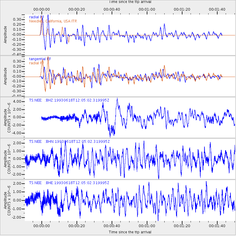
Signal To Noise
| Channel | StoN | STA | LTA |
| TS:NEE: :BHN:19930618T12:05:02.319995Z | 1.2774307 | 4.2027744E-7 | 3.2900218E-7 |
| TS:NEE: :BHE:19930618T12:05:02.319995Z | 1.1536294 | 6.465094E-7 | 5.604134E-7 |
| TS:NEE: :BHZ:19930618T12:05:02.319995Z | 1.8082237 | 1.0277436E-6 | 5.6837195E-7 |
| Arrivals |
| Ps | 3.7 SECOND |
| PpPs | 13 SECOND |
| PsPs/PpSs | 17 SECOND |


