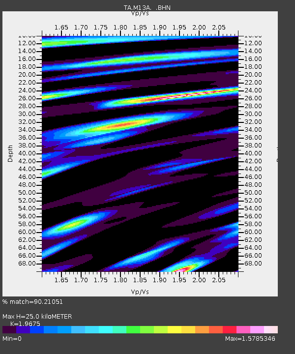
M13A Montello, NV, USA - Earthquake Result Viewer
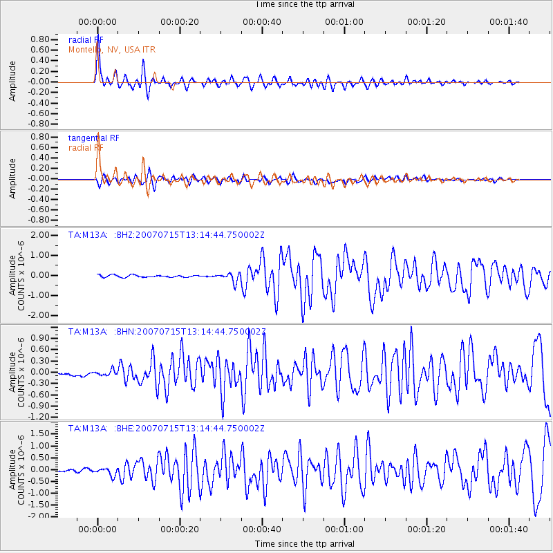
Earthquake location: Fox Islands, Aleutian Islands
Earthquake latitude/longitude: 52.5/-168.0
Earthquake time(UTC): 2007/07/15 (196) 13:08:00 GMT
Earthquake Depth: 10 km
Earthquake Magnitude: 5.8 MB, 5.9 MS, 6.1 MW, 6.0 MW
Earthquake Catalog/Contributor: WHDF/NEIC
Network: TA USArray Transportable Network (new EarthScope stations)
Station: M13A Montello, NV, USA
Lat/Lon: 41.36 N/114.17 W
Elevation: 1514 m
Distance: 37.6 deg
Az: 85.152 deg
Baz: 305.944 deg
Ray Param: 0.0760424
Estimated Moho Depth: 25.0 km
Estimated Crust Vp/Vs: 1.97
Assumed Crust Vp: 6.276 km/s
Estimated Crust Vs: 3.19 km/s
Estimated Crust Poisson's Ratio: 0.33
Radial Match: 90.21051 %
Radial Bump: 400
Transverse Match: 80.199875 %
Transverse Bump: 400
SOD ConfigId: 2564
Insert Time: 2010-03-07 04:45:07.249 +0000
GWidth: 2.5
Max Bumps: 400
Tol: 0.001

Signal To Noise

ChannelStoNSTALTA
TA:M13A: :BHN:20070715T13:14:44.750002Z0.96581917.944097E-88.225243E-8
TA:M13A: :BHE:20070715T13:14:44.750002Z4.0450581.6170797E-73.9976676E-8
TA:M13A: :BHZ:20070715T13:14:44.750002Z4.29253862.2882429E-75.3307453E-8
Arrivals
Ps4.1 SECOND
PpPs11 SECOND
PsPs/PpSs15 SECOND