You are here: Home > Network List > TA - USArray Transportable Network (new EarthScope stations) Stations List
> Station M13A Montello, NV, USA > Earthquake Result Viewer
M13A Montello, NV, USA - Earthquake Result Viewer
| Earthquake location: |
South Of Panama |
| Earthquake latitude/longitude: |
4.6/-78.5 |
| Earthquake time(UTC): |
2007/03/18 (077) 02:11:05 GMT |
| Earthquake Depth: |
8.0 km |
| Earthquake Magnitude: |
6.4 MB, 5.7 MS, 6.2 MW, 6.1 MW |
| Earthquake Catalog/Contributor: |
WHDF/NEIC |
|
| Network: |
TA USArray Transportable Network (new EarthScope stations) |
| Station: |
M13A Montello, NV, USA |
| Lat/Lon: |
41.36 N/114.17 W |
| Elevation: |
1514 m |
|
| Distance: |
48.6 deg |
| Az: |
324.161 deg |
| Baz: |
129.162 deg |
| Ray Param: |
0.06929084 |
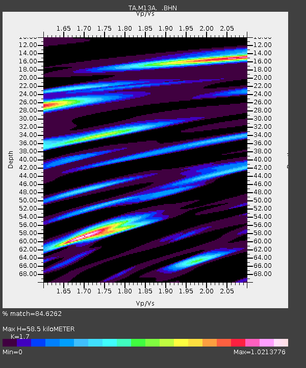
| Estimated Moho Depth: |
58.5 km |
| Estimated Crust Vp/Vs: |
1.70 |
| Assumed Crust Vp: |
6.276 km/s |
| Estimated Crust Vs: |
3.692 km/s |
| Estimated Crust Poisson's Ratio: |
0.24 |
|
| Radial Match: |
84.6262 % |
| Radial Bump: |
400 |
| Transverse Match: |
71.24685 % |
| Transverse Bump: |
400 |
| SOD ConfigId: |
2564 |
| Insert Time: |
2010-03-07 04:45:16.811 +0000 |
| GWidth: |
2.5 |
| Max Bumps: |
400 |
| Tol: |
0.001 |
|
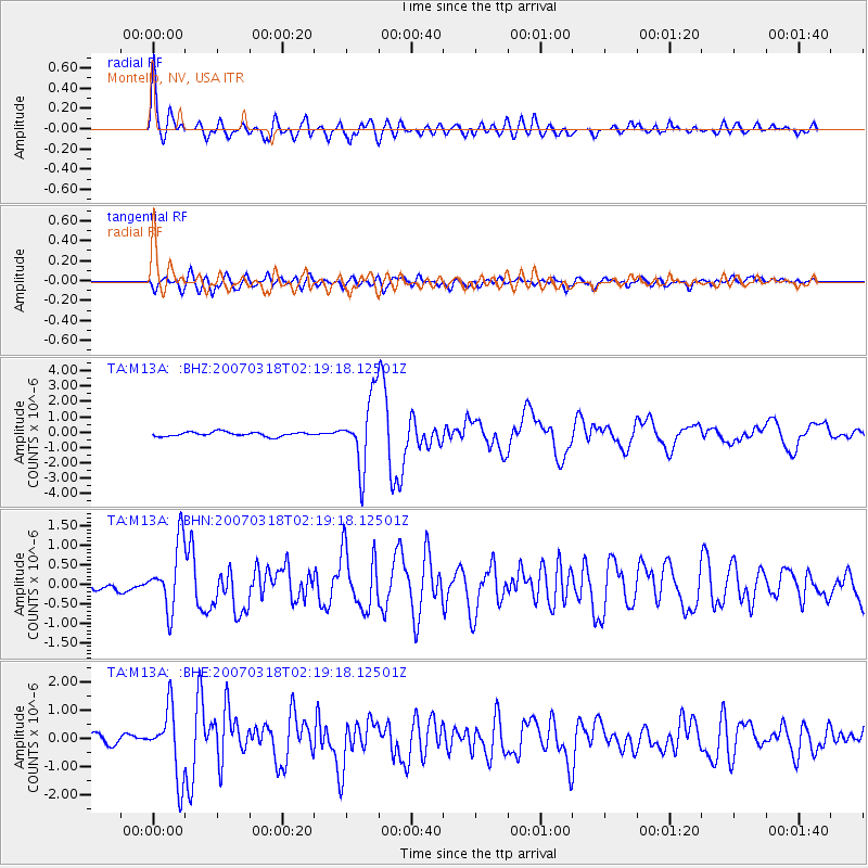
Signal To Noise
| Channel | StoN | STA | LTA |
| TA:M13A: :BHN:20070318T02:19:18.12501Z | 7.6059275 | 8.5633684E-7 | 1.1258808E-7 |
| TA:M13A: :BHE:20070318T02:19:18.12501Z | 8.233295 | 1.2032341E-6 | 1.4614247E-7 |
| TA:M13A: :BHZ:20070318T02:19:18.12501Z | 16.246908 | 2.2648512E-6 | 1.3940199E-7 |
| Arrivals |
| Ps | 6.9 SECOND |
| PpPs | 24 SECOND |
| PsPs/PpSs | 31 SECOND |


