You are here: Home > Network List > TS - TERRAscope (Southern California Seismic Network) Stations List
> Station NEE Needles, California, USA > Earthquake Result Viewer
NEE Needles, California, USA - Earthquake Result Viewer
| Earthquake location: |
Kermadec Islands Region |
| Earthquake latitude/longitude: |
-28.6/-176.9 |
| Earthquake time(UTC): |
1993/06/18 (169) 11:52:37 GMT |
| Earthquake Depth: |
33 km |
| Earthquake Magnitude: |
5.6 MB |
| Earthquake Catalog/Contributor: |
WHDF/NEIC |
|
| Network: |
TS TERRAscope (Southern California Seismic Network) |
| Station: |
NEE Needles, California, USA |
| Lat/Lon: |
34.82 N/114.60 W |
| Elevation: |
139 m |
|
| Distance: |
86.3 deg |
| Az: |
46.912 deg |
| Baz: |
231.298 deg |
| Ray Param: |
0.044115573 |
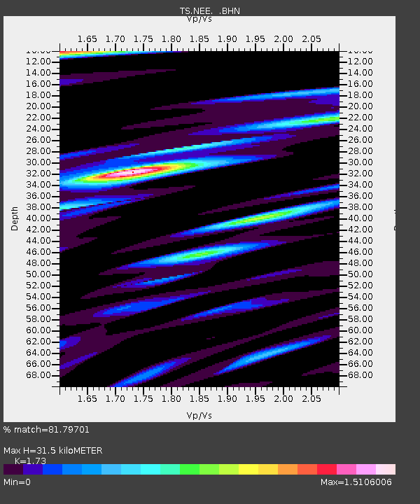
| Estimated Moho Depth: |
31.5 km |
| Estimated Crust Vp/Vs: |
1.73 |
| Assumed Crust Vp: |
6.276 km/s |
| Estimated Crust Vs: |
3.628 km/s |
| Estimated Crust Poisson's Ratio: |
0.25 |
|
| Radial Match: |
81.79701 % |
| Radial Bump: |
400 |
| Transverse Match: |
74.90266 % |
| Transverse Bump: |
400 |
| SOD ConfigId: |
17000 |
| Insert Time: |
2010-02-26 14:30:19.862 +0000 |
| GWidth: |
2.5 |
| Max Bumps: |
400 |
| Tol: |
0.001 |
|

Signal To Noise
| Channel | StoN | STA | LTA |
| TS:NEE: :BHN:19930618T12:04:44.87002Z | 0.8448598 | 3.2126377E-7 | 3.802569E-7 |
| TS:NEE: :BHE:19930618T12:04:44.87002Z | 1.4167153 | 7.119159E-7 | 5.025116E-7 |
| TS:NEE: :BHZ:19930618T12:04:44.87002Z | 1.0476354 | 3.7389967E-7 | 3.5689868E-7 |
| Arrivals |
| Ps | 3.7 SECOND |
| PpPs | 13 SECOND |
| PsPs/PpSs | 17 SECOND |


