You are here: Home > Network List > TA - USArray Transportable Network (new EarthScope stations) Stations List
> Station M13A Montello, NV, USA > Earthquake Result Viewer
M13A Montello, NV, USA - Earthquake Result Viewer

| Earthquake location: |
East Of Kuril Islands |
| Earthquake latitude/longitude: |
46.5/154.7 |
| Earthquake time(UTC): |
2006/11/15 (319) 11:40:55 GMT |
| Earthquake Depth: |
10 km |
| Earthquake Magnitude: |
6.4 MB |
| Earthquake Catalog/Contributor: |
WHDF/NEIC |
|
| Network: |
TA USArray Transportable Network (new EarthScope stations) |
| Station: |
M13A Montello, NV, USA |
| Lat/Lon: |
41.36 N/114.17 W |
| Elevation: |
1514 m |
|
| Distance: |
62.2 deg |
| Az: |
58.269 deg |
| Baz: |
308.672 deg |
| Ray Param: |
0.060357984 |
| Estimated Moho Depth: |
10.5 km |
| Estimated Crust Vp/Vs: |
1.60 |
| Assumed Crust Vp: |
6.276 km/s |
| Estimated Crust Vs: |
3.922 km/s |
| Estimated Crust Poisson's Ratio: |
0.18 |
|
| Radial Match: |
94.213875 % |
| Radial Bump: |
249 |
| Transverse Match: |
91.31046 % |
| Transverse Bump: |
163 |
| SOD ConfigId: |
2564 |
| Insert Time: |
2010-03-07 04:45:25.871 +0000 |
| GWidth: |
2.5 |
| Max Bumps: |
400 |
| Tol: |
0.001 |
|
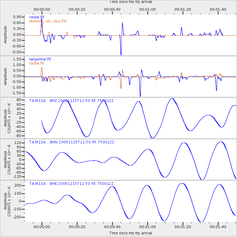
Signal To Noise
| Channel | StoN | STA | LTA |
| TA:M13A: :BHN:20061115T11:50:45.750012Z | 2.3109207 | 7.341634E-5 | 3.17693E-5 |
| TA:M13A: :BHE:20061115T11:50:45.750012Z | 0.52069515 | 1.7746133E-5 | 3.408162E-5 |
| TA:M13A: :BHZ:20061115T11:50:45.750012Z | 1.0006679 | 5.2029365E-5 | 5.1994633E-5 |
| Arrivals |
| Ps | 1.1 SECOND |
| PpPs | 4.1 SECOND |
| PsPs/PpSs | 5.2 SECOND |


