You are here: Home > Network List > TA - USArray Transportable Network (new EarthScope stations) Stations List
> Station M13A Montello, NV, USA > Earthquake Result Viewer
M13A Montello, NV, USA - Earthquake Result Viewer
| Earthquake location: |
East Of Kuril Islands |
| Earthquake latitude/longitude: |
46.7/155.3 |
| Earthquake time(UTC): |
2006/11/15 (319) 11:34:58 GMT |
| Earthquake Depth: |
10 km |
| Earthquake Magnitude: |
6.4 MB |
| Earthquake Catalog/Contributor: |
WHDF/NEIC |
|
| Network: |
TA USArray Transportable Network (new EarthScope stations) |
| Station: |
M13A Montello, NV, USA |
| Lat/Lon: |
41.36 N/114.17 W |
| Elevation: |
1514 m |
|
| Distance: |
61.8 deg |
| Az: |
58.653 deg |
| Baz: |
308.599 deg |
| Ray Param: |
0.060637344 |
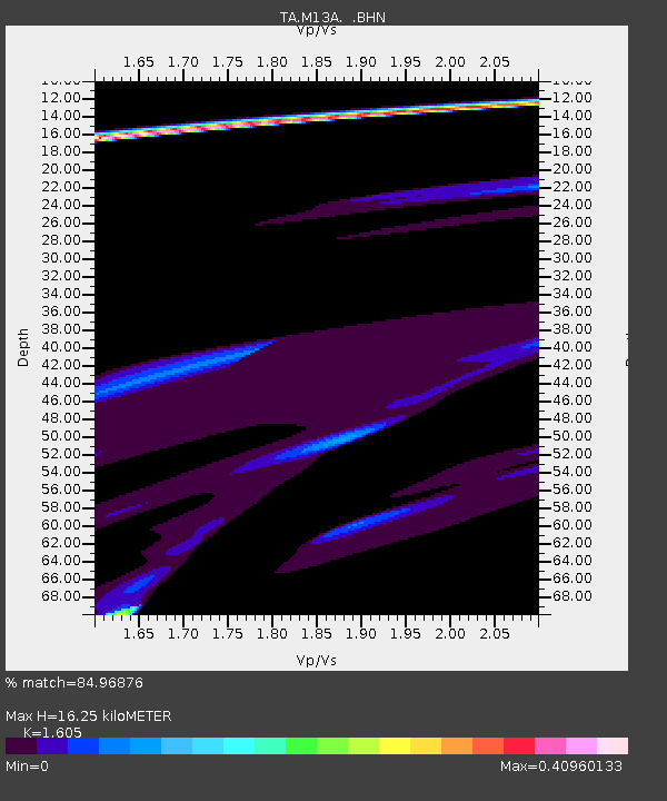
| Estimated Moho Depth: |
16.25 km |
| Estimated Crust Vp/Vs: |
1.61 |
| Assumed Crust Vp: |
6.276 km/s |
| Estimated Crust Vs: |
3.91 km/s |
| Estimated Crust Poisson's Ratio: |
0.18 |
|
| Radial Match: |
84.96876 % |
| Radial Bump: |
319 |
| Transverse Match: |
52.660988 % |
| Transverse Bump: |
198 |
| SOD ConfigId: |
2564 |
| Insert Time: |
2010-03-07 04:45:27.804 +0000 |
| GWidth: |
2.5 |
| Max Bumps: |
400 |
| Tol: |
0.001 |
|

Signal To Noise
| Channel | StoN | STA | LTA |
| TA:M13A: :BHN:20061115T11:44:45.973018Z | 1.3289024 | 4.2496962E-5 | 3.1978994E-5 |
| TA:M13A: :BHE:20061115T11:44:45.973018Z | 0.567845 | 4.467895E-5 | 7.8681594E-5 |
| TA:M13A: :BHZ:20061115T11:44:45.973018Z | 3.4708352 | 1.7025828E-4 | 4.9053982E-5 |
| Arrivals |
| Ps | 1.6 SECOND |
| PpPs | 6.4 SECOND |
| PsPs/PpSs | 8.1 SECOND |


