You are here: Home > Network List > TA - USArray Transportable Network (new EarthScope stations) Stations List
> Station M13A Montello, NV, USA > Earthquake Result Viewer
M13A Montello, NV, USA - Earthquake Result Viewer
| Earthquake location: |
Kuril Islands |
| Earthquake latitude/longitude: |
48.3/154.2 |
| Earthquake time(UTC): |
2006/11/12 (316) 21:27:42 GMT |
| Earthquake Depth: |
36 km |
| Earthquake Magnitude: |
6.1 MB, 5.4 MS, 5.9 MW, 5.9 MW |
| Earthquake Catalog/Contributor: |
WHDF/NEIC |
|
| Network: |
TA USArray Transportable Network (new EarthScope stations) |
| Station: |
M13A Montello, NV, USA |
| Lat/Lon: |
41.36 N/114.17 W |
| Elevation: |
1514 m |
|
| Distance: |
61.6 deg |
| Az: |
58.826 deg |
| Baz: |
310.605 deg |
| Ray Param: |
0.060722224 |
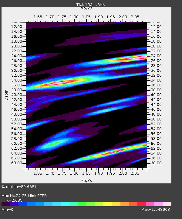
| Estimated Moho Depth: |
24.25 km |
| Estimated Crust Vp/Vs: |
2.09 |
| Assumed Crust Vp: |
6.276 km/s |
| Estimated Crust Vs: |
3.01 km/s |
| Estimated Crust Poisson's Ratio: |
0.35 |
|
| Radial Match: |
80.6581 % |
| Radial Bump: |
400 |
| Transverse Match: |
73.85501 % |
| Transverse Bump: |
400 |
| SOD ConfigId: |
2564 |
| Insert Time: |
2010-03-07 04:45:30.573 +0000 |
| GWidth: |
2.5 |
| Max Bumps: |
400 |
| Tol: |
0.001 |
|
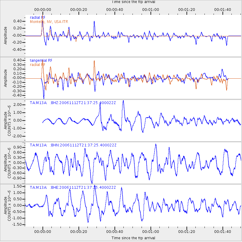
Signal To Noise
| Channel | StoN | STA | LTA |
| TA:M13A: :BHN:20061112T21:37:25.400022Z | 1.5217713 | 3.9713441E-7 | 2.6096853E-7 |
| TA:M13A: :BHE:20061112T21:37:25.400022Z | 2.6855288 | 4.702852E-7 | 1.7511827E-7 |
| TA:M13A: :BHZ:20061112T21:37:25.400022Z | 4.0007195 | 9.1130744E-7 | 2.2778589E-7 |
| Arrivals |
| Ps | 4.3 SECOND |
| PpPs | 11 SECOND |
| PsPs/PpSs | 16 SECOND |


