You are here: Home > Network List > TA - USArray Transportable Network (new EarthScope stations) Stations List
> Station M13A Montello, NV, USA > Earthquake Result Viewer
M13A Montello, NV, USA - Earthquake Result Viewer
| Earthquake location: |
Kuril Islands |
| Earthquake latitude/longitude: |
46.5/153.2 |
| Earthquake time(UTC): |
2006/10/01 (274) 09:06:02 GMT |
| Earthquake Depth: |
19 km |
| Earthquake Magnitude: |
6.1 MB, 6.4 MS, 6.6 MW, 6.5 MW |
| Earthquake Catalog/Contributor: |
WHDF/NEIC |
|
| Network: |
TA USArray Transportable Network (new EarthScope stations) |
| Station: |
M13A Montello, NV, USA |
| Lat/Lon: |
41.36 N/114.17 W |
| Elevation: |
1514 m |
|
| Distance: |
63.1 deg |
| Az: |
57.471 deg |
| Baz: |
309.275 deg |
| Ray Param: |
0.059766322 |
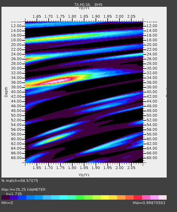
| Estimated Moho Depth: |
35.25 km |
| Estimated Crust Vp/Vs: |
1.74 |
| Assumed Crust Vp: |
6.276 km/s |
| Estimated Crust Vs: |
3.617 km/s |
| Estimated Crust Poisson's Ratio: |
0.25 |
|
| Radial Match: |
86.57075 % |
| Radial Bump: |
400 |
| Transverse Match: |
80.995544 % |
| Transverse Bump: |
400 |
| SOD ConfigId: |
2665 |
| Insert Time: |
2010-03-07 04:45:36.108 +0000 |
| GWidth: |
2.5 |
| Max Bumps: |
400 |
| Tol: |
0.001 |
|

Signal To Noise
| Channel | StoN | STA | LTA |
| TA:M13A: :BHN:20061001T09:15:57.525017Z | 1.1769208 | 1.7975783E-7 | 1.5273572E-7 |
| TA:M13A: :BHE:20061001T09:15:57.525017Z | 1.330999 | 2.2495637E-7 | 1.6901318E-7 |
| TA:M13A: :BHZ:20061001T09:15:57.525017Z | 2.8943155 | 4.4493325E-7 | 1.5372659E-7 |
| Arrivals |
| Ps | 4.3 SECOND |
| PpPs | 15 SECOND |
| PsPs/PpSs | 19 SECOND |


