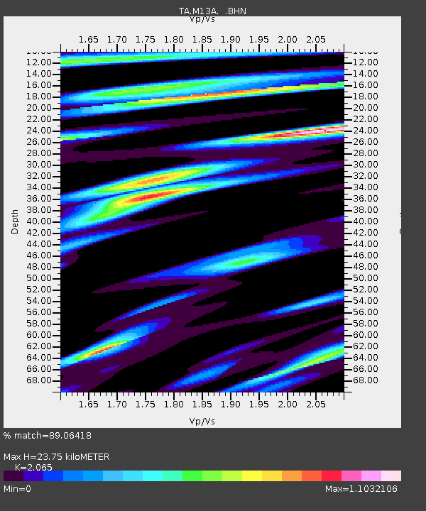
M13A Montello, NV, USA - Earthquake Result Viewer
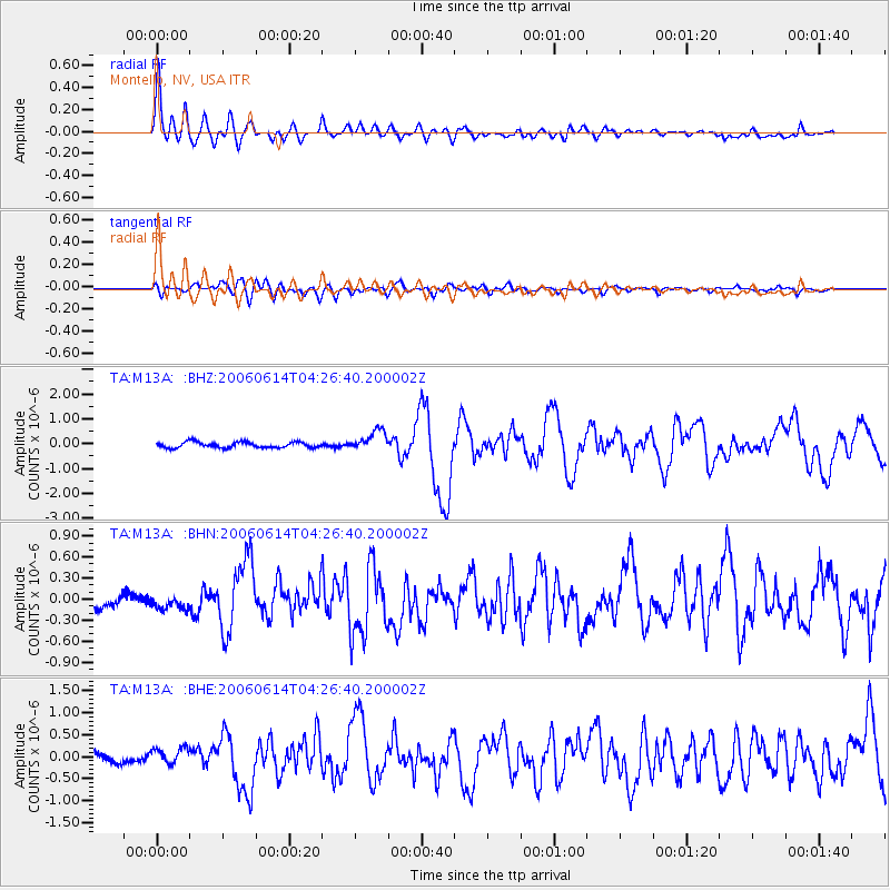
Earthquake location: Rat Islands, Aleutian Islands
Earthquake latitude/longitude: 51.8/177.1
Earthquake time(UTC): 2006/06/14 (165) 04:18:42 GMT
Earthquake Depth: 14 km
Earthquake Magnitude: 5.9 MB, 6.4 MS, 6.4 MW, 6.4 MW
Earthquake Catalog/Contributor: WHDF/NEIC
Network: TA USArray Transportable Network (new EarthScope stations)
Station: M13A Montello, NV, USA
Lat/Lon: 41.36 N/114.17 W
Elevation: 1514 m
Distance: 46.7 deg
Az: 74.428 deg
Baz: 307.299 deg
Ray Param: 0.070439585
Estimated Moho Depth: 23.75 km
Estimated Crust Vp/Vs: 2.07
Assumed Crust Vp: 6.276 km/s
Estimated Crust Vs: 3.039 km/s
Estimated Crust Poisson's Ratio: 0.35
Radial Match: 89.06418 %
Radial Bump: 400
Transverse Match: 74.95585 %
Transverse Bump: 400
SOD ConfigId: 5745
Insert Time: 2010-03-07 04:45:51.016 +0000
GWidth: 2.5
Max Bumps: 400
Tol: 0.001

Signal To Noise

ChannelStoNSTALTA
TA:M13A: :BHN:20060614T04:26:40.200002Z1.38759051.1541474E-78.317637E-8
TA:M13A: :BHE:20060614T04:26:40.200002Z1.6102131.8477616E-71.14752616E-7
TA:M13A: :BHZ:20060614T04:26:40.200002Z3.58689674.1086236E-71.1454536E-7
Arrivals
Ps4.2 SECOND
PpPs11 SECOND
PsPs/PpSs15 SECOND