You are here: Home > Network List > TA - USArray Transportable Network (new EarthScope stations) Stations List
> Station M13A Montello, NV, USA > Earthquake Result Viewer
M13A Montello, NV, USA - Earthquake Result Viewer
| Earthquake location: |
Tonga Islands |
| Earthquake latitude/longitude: |
-20.6/-173.9 |
| Earthquake time(UTC): |
2006/05/17 (137) 03:06:16 GMT |
| Earthquake Depth: |
10 km |
| Earthquake Magnitude: |
5.8 MB, 5.8 MS, 6.0 MW, 5.8 MW |
| Earthquake Catalog/Contributor: |
WHDF/NEIC |
|
| Network: |
TA USArray Transportable Network (new EarthScope stations) |
| Station: |
M13A Montello, NV, USA |
| Lat/Lon: |
41.36 N/114.17 W |
| Elevation: |
1514 m |
|
| Distance: |
82.9 deg |
| Az: |
40.963 deg |
| Baz: |
234.655 deg |
| Ray Param: |
0.046589594 |
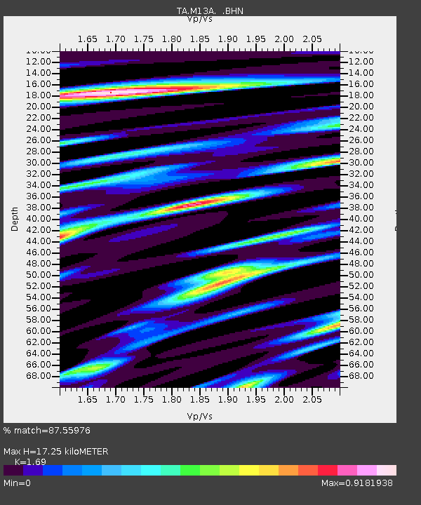
| Estimated Moho Depth: |
17.25 km |
| Estimated Crust Vp/Vs: |
1.69 |
| Assumed Crust Vp: |
6.276 km/s |
| Estimated Crust Vs: |
3.713 km/s |
| Estimated Crust Poisson's Ratio: |
0.23 |
|
| Radial Match: |
87.55976 % |
| Radial Bump: |
393 |
| Transverse Match: |
72.64526 % |
| Transverse Bump: |
385 |
| SOD ConfigId: |
2669 |
| Insert Time: |
2010-03-07 04:45:52.456 +0000 |
| GWidth: |
2.5 |
| Max Bumps: |
400 |
| Tol: |
0.001 |
|

Signal To Noise
| Channel | StoN | STA | LTA |
| TA:M13A: :BHN:20060517T03:18:09.32502Z | 2.1240659 | 1.6001705E-7 | 7.5335265E-8 |
| TA:M13A: :BHE:20060517T03:18:09.32502Z | 1.599888 | 1.4270286E-7 | 8.919554E-8 |
| TA:M13A: :BHZ:20060517T03:18:09.32502Z | 5.820779 | 4.0638125E-7 | 6.981561E-8 |
| Arrivals |
| Ps | 1.9 SECOND |
| PpPs | 7.2 SECOND |
| PsPs/PpSs | 9.2 SECOND |


