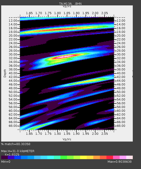
M13A Montello, NV, USA - Earthquake Result Viewer

Earthquake location: New Britain Region, P.N.G.
Earthquake latitude/longitude: -5.7/151.1
Earthquake time(UTC): 2006/05/28 (148) 03:12:08 GMT
Earthquake Depth: 34 km
Earthquake Magnitude: 5.9 MB, 6.6 MS, 6.5 MW, 6.4 MW
Earthquake Catalog/Contributor: WHDF/NEIC
Network: TA USArray Transportable Network (new EarthScope stations)
Station: M13A Montello, NV, USA
Lat/Lon: 41.36 N/114.17 W
Elevation: 1514 m
Distance: 97.3 deg
Az: 49.141 deg
Baz: 268.793 deg
Ray Param: 0.040246736
Estimated Moho Depth: 31.0 km
Estimated Crust Vp/Vs: 1.83
Assumed Crust Vp: 6.276 km/s
Estimated Crust Vs: 3.425 km/s
Estimated Crust Poisson's Ratio: 0.29
Radial Match: 80.30358 %
Radial Bump: 400
Transverse Match: 72.62485 %
Transverse Bump: 400
SOD ConfigId: 2669
Insert Time: 2010-03-07 04:45:55.389 +0000
GWidth: 2.5
Max Bumps: 400
Tol: 0.001

Signal To Noise

ChannelStoNSTALTA
TA:M13A: :BHN:20060528T03:25:06.725027Z0.98028827.7918166E-87.9484956E-8
TA:M13A: :BHE:20060528T03:25:06.725027Z1.33132051.264926E-79.501288E-8
TA:M13A: :BHZ:20060528T03:25:06.725027Z6.68060974.607117E-76.896252E-8
Arrivals
Ps4.2 SECOND
PpPs14 SECOND
PsPs/PpSs18 SECOND