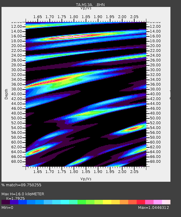
M13A Montello, NV, USA - Earthquake Result Viewer
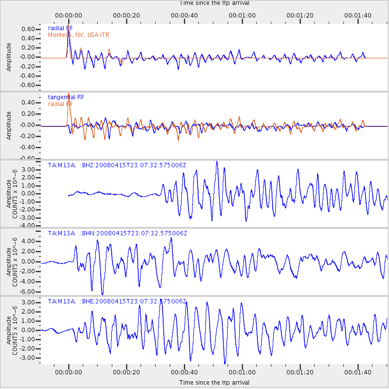
Earthquake location: Andreanof Islands, Aleutian Is.
Earthquake latitude/longitude: 51.9/-179.4
Earthquake time(UTC): 2008/04/15 (106) 22:59:51 GMT
Earthquake Depth: 10 km
Earthquake Magnitude: 6.1 MB, 6.4 MS, 6.4 MW, 6.4 MW
Earthquake Catalog/Contributor: WHDF/NEIC
Network: TA USArray Transportable Network (new EarthScope stations)
Station: M13A Montello, NV, USA
Lat/Lon: 41.36 N/114.17 W
Elevation: 1514 m
Distance: 44.6 deg
Az: 76.778 deg
Baz: 306.669 deg
Ray Param: 0.07182891
Estimated Moho Depth: 16.0 km
Estimated Crust Vp/Vs: 1.79
Assumed Crust Vp: 6.276 km/s
Estimated Crust Vs: 3.501 km/s
Estimated Crust Poisson's Ratio: 0.27
Radial Match: 89.758255 %
Radial Bump: 400
Transverse Match: 82.32562 %
Transverse Bump: 400
SOD ConfigId: 2504
Insert Time: 2010-03-07 04:45:59.267 +0000
GWidth: 2.5
Max Bumps: 400
Tol: 0.001

Signal To Noise

ChannelStoNSTALTA
TA:M13A: :BHN:20080415T23:07:32.575006Z7.25572971.2091705E-61.6665042E-7
TA:M13A: :BHE:20080415T23:07:32.575006Z1.16705213.9919925E-73.4205777E-7
TA:M13A: :BHZ:20080415T23:07:32.575006Z3.70220285.422768E-71.4647408E-7
Arrivals
Ps2.1 SECOND
PpPs6.7 SECOND
PsPs/PpSs8.8 SECOND