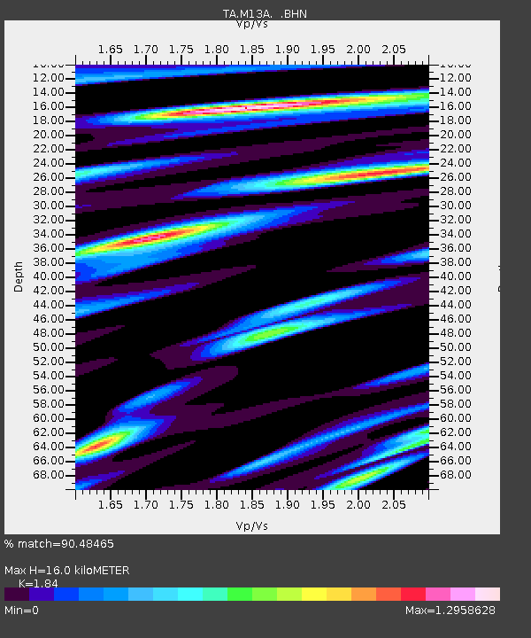
M13A Montello, NV, USA - Earthquake Result Viewer
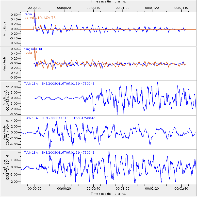
Earthquake location: Andreanof Islands, Aleutian Is.
Earthquake latitude/longitude: 51.9/-179.2
Earthquake time(UTC): 2008/04/16 (107) 05:54:19 GMT
Earthquake Depth: 13 km
Earthquake Magnitude: 6.1 MB, 6.5 MS, 6.6 MW, 6.6 MW
Earthquake Catalog/Contributor: WHDF/NEIC
Network: TA USArray Transportable Network (new EarthScope stations)
Station: M13A Montello, NV, USA
Lat/Lon: 41.36 N/114.17 W
Elevation: 1514 m
Distance: 44.5 deg
Az: 76.926 deg
Baz: 306.664 deg
Ray Param: 0.07189635
Estimated Moho Depth: 16.0 km
Estimated Crust Vp/Vs: 1.84
Assumed Crust Vp: 6.276 km/s
Estimated Crust Vs: 3.411 km/s
Estimated Crust Poisson's Ratio: 0.29
Radial Match: 90.48465 %
Radial Bump: 400
Transverse Match: 84.94417 %
Transverse Bump: 400
SOD ConfigId: 2504
Insert Time: 2010-03-07 04:46:00.627 +0000
GWidth: 2.5
Max Bumps: 400
Tol: 0.001

Signal To Noise

ChannelStoNSTALTA
TA:M13A: :BHN:20080416T06:01:59.475004Z3.96920756.719917E-71.6930123E-7
TA:M13A: :BHE:20080416T06:01:59.475004Z1.10634282.1398306E-71.934148E-7
TA:M13A: :BHZ:20080416T06:01:59.475004Z1.84628773.0160473E-71.6335738E-7
Arrivals
Ps2.3 SECOND
PpPs6.8 SECOND
PsPs/PpSs9.1 SECOND