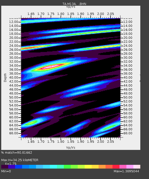
M13A Montello, NV, USA - Earthquake Result Viewer
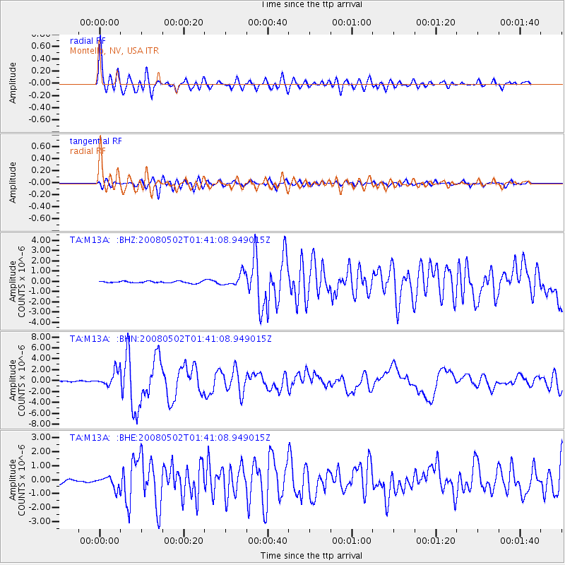
Earthquake location: Andreanof Islands, Aleutian Is.
Earthquake latitude/longitude: 51.9/-177.5
Earthquake time(UTC): 2008/05/02 (123) 01:33:37 GMT
Earthquake Depth: 14 km
Earthquake Magnitude: 6.3 MB, 6.8 MS, 6.6 MW, 6.6 MW
Earthquake Catalog/Contributor: WHDF/NEIC
Network: TA USArray Transportable Network (new EarthScope stations)
Station: M13A Montello, NV, USA
Lat/Lon: 41.36 N/114.17 W
Elevation: 1514 m
Distance: 43.5 deg
Az: 77.967 deg
Baz: 306.326 deg
Ray Param: 0.0725207
Estimated Moho Depth: 34.25 km
Estimated Crust Vp/Vs: 1.75
Assumed Crust Vp: 6.276 km/s
Estimated Crust Vs: 3.586 km/s
Estimated Crust Poisson's Ratio: 0.26
Radial Match: 90.81662 %
Radial Bump: 400
Transverse Match: 74.14682 %
Transverse Bump: 400
SOD ConfigId: 2504
Insert Time: 2010-03-07 04:46:04.962 +0000
GWidth: 2.5
Max Bumps: 400
Tol: 0.001

Signal To Noise

ChannelStoNSTALTA
TA:M13A: :BHN:20080502T01:41:08.949015Z11.9688531.428757E-61.1937291E-7
TA:M13A: :BHE:20080502T01:41:08.949015Z2.06071114.4291488E-72.1493301E-7
TA:M13A: :BHZ:20080502T01:41:08.949015Z7.6031936.390768E-78.405374E-8
Arrivals
Ps4.4 SECOND
PpPs14 SECOND
PsPs/PpSs18 SECOND