You are here: Home > Network List > TA - USArray Transportable Network (new EarthScope stations) Stations List
> Station M13A Montello, NV, USA > Earthquake Result Viewer
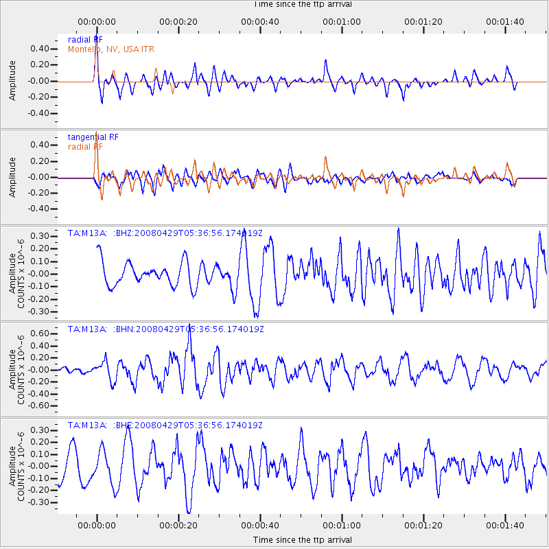
M13A Montello, NV, USA - Earthquake Result Viewer
*The percent match for this event was below the threshold and hence no stack was calculated.
| Earthquake location: |
Hokkaido, Japan Region |
| Earthquake latitude/longitude: |
41.5/142.0 |
| Earthquake time(UTC): |
2008/04/29 (120) 05:26:04 GMT |
| Earthquake Depth: |
47 km |
| Earthquake Magnitude: |
5.5 MB, 5.2 MS, 5.8 MW, 5.8 MW |
| Earthquake Catalog/Contributor: |
WHDF/NEIC |
|
| Network: |
TA USArray Transportable Network (new EarthScope stations) |
| Station: |
M13A Montello, NV, USA |
| Lat/Lon: |
41.36 N/114.17 W |
| Elevation: |
1514 m |
|
| Distance: |
72.6 deg |
| Az: |
50.005 deg |
| Baz: |
310.091 deg |
| Ray Param: |
$rayparam |
*The percent match for this event was below the threshold and hence was not used in the summary stack. |
|
| Radial Match: |
59.982086 % |
| Radial Bump: |
400 |
| Transverse Match: |
51.680412 % |
| Transverse Bump: |
400 |
| SOD ConfigId: |
2504 |
| Insert Time: |
2010-03-07 04:46:23.009 +0000 |
| GWidth: |
2.5 |
| Max Bumps: |
400 |
| Tol: |
0.001 |
|
Signal To Noise
| Channel | StoN | STA | LTA |
| TA:M13A: :BHN:20080429T05:36:56.174019Z | 3.3246274 | 1.6272654E-7 | 4.8945797E-8 |
| TA:M13A: :BHE:20080429T05:36:56.174019Z | 1.5019861 | 1.4063885E-7 | 9.363525E-8 |
| TA:M13A: :BHZ:20080429T05:36:56.174019Z | 1.017701 | 9.564607E-8 | 9.398248E-8 |
| Arrivals |
| Ps | |
| PpPs | |
| PsPs/PpSs | |


