You are here: Home > Network List > TA - USArray Transportable Network (new EarthScope stations) Stations List
> Station M13A Montello, NV, USA > Earthquake Result Viewer
M13A Montello, NV, USA - Earthquake Result Viewer
*The percent match for this event was below the threshold and hence no stack was calculated.
| Earthquake location: |
Kuril Islands |
| Earthquake latitude/longitude: |
46.5/153.3 |
| Earthquake time(UTC): |
2008/06/23 (175) 12:32:12 GMT |
| Earthquake Depth: |
10 km |
| Earthquake Magnitude: |
5.6 MB, 5.2 MS, 5.6 MW, 5.6 MW |
| Earthquake Catalog/Contributor: |
WHDF/NEIC |
|
| Network: |
TA USArray Transportable Network (new EarthScope stations) |
| Station: |
M13A Montello, NV, USA |
| Lat/Lon: |
41.36 N/114.17 W |
| Elevation: |
1514 m |
|
| Distance: |
63.1 deg |
| Az: |
57.49 deg |
| Baz: |
309.275 deg |
| Ray Param: |
$rayparam |
*The percent match for this event was below the threshold and hence was not used in the summary stack. |
|
| Radial Match: |
60.922318 % |
| Radial Bump: |
400 |
| Transverse Match: |
68.84907 % |
| Transverse Bump: |
400 |
| SOD ConfigId: |
2504 |
| Insert Time: |
2010-03-07 04:46:29.767 +0000 |
| GWidth: |
2.5 |
| Max Bumps: |
400 |
| Tol: |
0.001 |
|
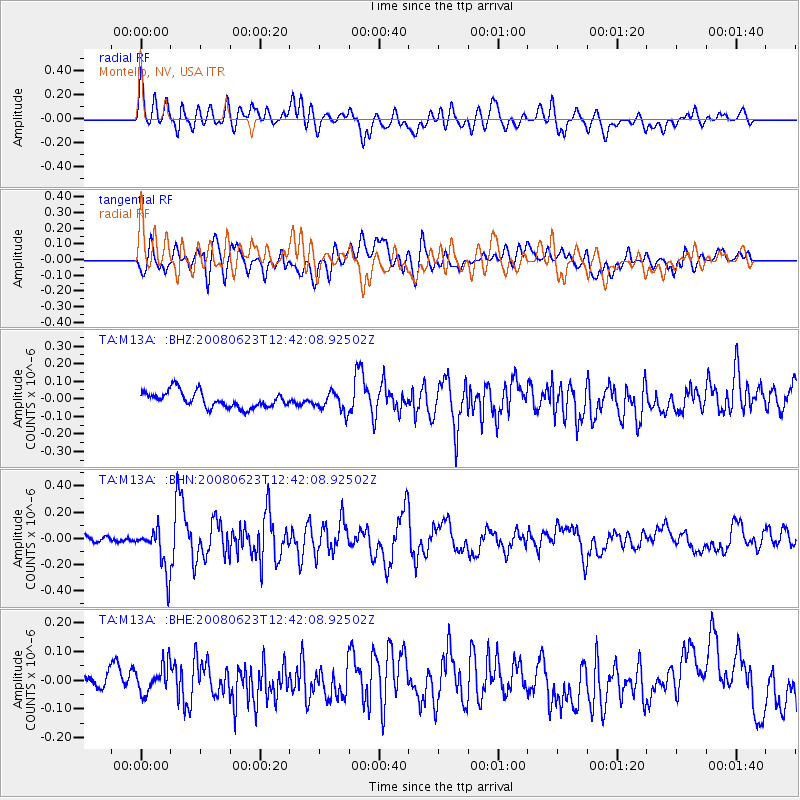
Signal To Noise
| Channel | StoN | STA | LTA |
| TA:M13A: :BHN:20080623T12:42:08.92502Z | 3.484959 | 1.650423E-7 | 4.7358462E-8 |
| TA:M13A: :BHE:20080623T12:42:08.92502Z | 1.2527373 | 4.8665488E-8 | 3.8847322E-8 |
| TA:M13A: :BHZ:20080623T12:42:08.92502Z | 1.1959974 | 5.4236793E-8 | 4.534859E-8 |
| Arrivals |
| Ps | |
| PpPs | |
| PsPs/PpSs | |


