You are here: Home > Network List > TA - USArray Transportable Network (new EarthScope stations) Stations List
> Station M13A Montello, NV, USA > Earthquake Result Viewer
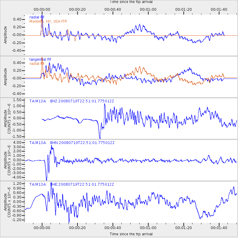
M13A Montello, NV, USA - Earthquake Result Viewer
*The percent match for this event was below the threshold and hence no stack was calculated.
| Earthquake location: |
Fiji Islands Region |
| Earthquake latitude/longitude: |
-17.3/-177.3 |
| Earthquake time(UTC): |
2008/07/19 (201) 22:39:52 GMT |
| Earthquake Depth: |
391 km |
| Earthquake Magnitude: |
5.9 MB, 6.4 MW, 6.4 MW |
| Earthquake Catalog/Contributor: |
WHDF/NEIC |
|
| Network: |
TA USArray Transportable Network (new EarthScope stations) |
| Station: |
M13A Montello, NV, USA |
| Lat/Lon: |
41.36 N/114.17 W |
| Elevation: |
1514 m |
|
| Distance: |
82.5 deg |
| Az: |
42.635 deg |
| Baz: |
239.25 deg |
| Ray Param: |
$rayparam |
*The percent match for this event was below the threshold and hence was not used in the summary stack. |
|
| Radial Match: |
63.728863 % |
| Radial Bump: |
400 |
| Transverse Match: |
60.660007 % |
| Transverse Bump: |
400 |
| SOD ConfigId: |
2504 |
| Insert Time: |
2010-03-07 04:46:36.057 +0000 |
| GWidth: |
2.5 |
| Max Bumps: |
400 |
| Tol: |
0.001 |
|
Signal To Noise
| Channel | StoN | STA | LTA |
| TA:M13A: :BHN:20080719T22:51:01.775012Z | 27.030792 | 1.8118901E-6 | 6.70306E-8 |
| TA:M13A: :BHE:20080719T22:51:01.775012Z | 1.7296212 | 5.159037E-7 | 2.9827558E-7 |
| TA:M13A: :BHZ:20080719T22:51:01.775012Z | 5.6946645 | 7.2239857E-7 | 1.2685534E-7 |
| Arrivals |
| Ps | |
| PpPs | |
| PsPs/PpSs | |


