You are here: Home > Network List > TA - USArray Transportable Network (new EarthScope stations) Stations List
> Station G21K Allakaket, AK, USA > Earthquake Result Viewer
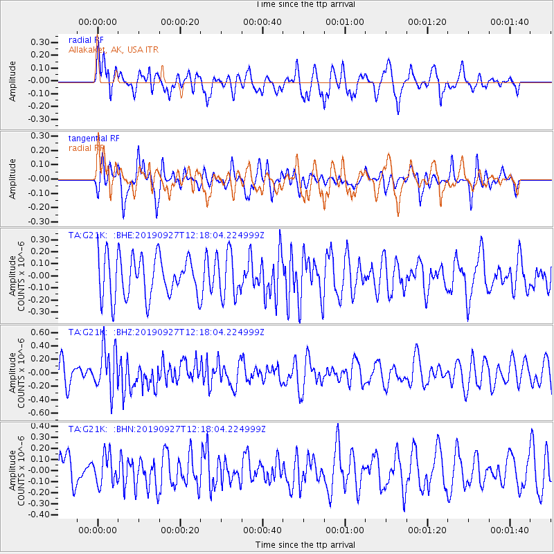
G21K Allakaket, AK, USA - Earthquake Result Viewer
*The percent match for this event was below the threshold and hence no stack was calculated.
| Earthquake location: |
Kermadec Islands, New Zealand |
| Earthquake latitude/longitude: |
-30.1/-177.8 |
| Earthquake time(UTC): |
2019/09/27 (270) 12:05:02 GMT |
| Earthquake Depth: |
35 km |
| Earthquake Magnitude: |
6.0 Mww |
| Earthquake Catalog/Contributor: |
NEIC PDE/us |
|
| Network: |
TA USArray Transportable Network (new EarthScope stations) |
| Station: |
G21K Allakaket, AK, USA |
| Lat/Lon: |
66.52 N/153.51 W |
| Elevation: |
446 m |
|
| Distance: |
98.1 deg |
| Az: |
9.597 deg |
| Baz: |
201.125 deg |
| Ray Param: |
$rayparam |
*The percent match for this event was below the threshold and hence was not used in the summary stack. |
|
| Radial Match: |
55.71104 % |
| Radial Bump: |
400 |
| Transverse Match: |
47.46921 % |
| Transverse Bump: |
400 |
| SOD ConfigId: |
19053131 |
| Insert Time: |
2019-10-11 12:13:56.195 +0000 |
| GWidth: |
2.5 |
| Max Bumps: |
400 |
| Tol: |
0.001 |
|
Signal To Noise
| Channel | StoN | STA | LTA |
| TA:G21K: :BHZ:20190927T12:18:04.224999Z | 2.0105493 | 3.293379E-7 | 1.6380493E-7 |
| TA:G21K: :BHN:20190927T12:18:04.224999Z | 0.9016369 | 1.3608665E-7 | 1.5093288E-7 |
| TA:G21K: :BHE:20190927T12:18:04.224999Z | 1.0741725 | 1.822078E-7 | 1.6962619E-7 |
| Arrivals |
| Ps | |
| PpPs | |
| PsPs/PpSs | |


