You are here: Home > Network List > GT - Global Telemetered Seismograph Network (USAF/USGS) Stations List
> Station LPAZ La Paz , Bolivia > Earthquake Result Viewer
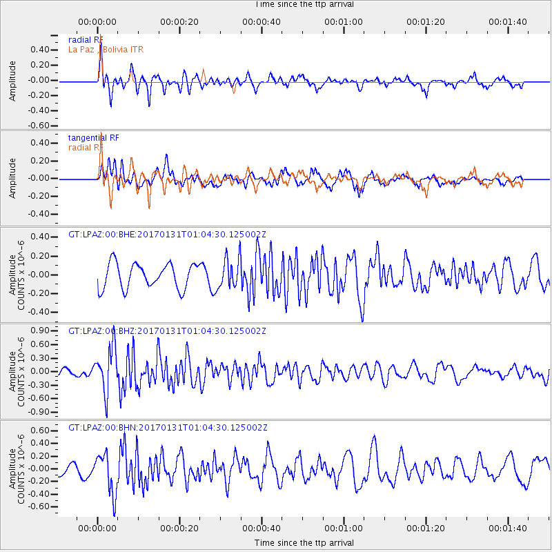
LPAZ La Paz , Bolivia - Earthquake Result Viewer
*The percent match for this event was below the threshold and hence no stack was calculated.
| Earthquake location: |
Northern Mid-Atlantic Ridge |
| Earthquake latitude/longitude: |
34.6/-36.4 |
| Earthquake time(UTC): |
2017/01/31 (031) 00:55:02 GMT |
| Earthquake Depth: |
10 km |
| Earthquake Magnitude: |
5.6 Mwc |
| Earthquake Catalog/Contributor: |
NEIC PDE/us |
|
| Network: |
GT Global Telemetered Seismograph Network (USAF/USGS) |
| Station: |
LPAZ La Paz , Bolivia |
| Lat/Lon: |
16.17 S/68.08 W |
| Elevation: |
4817 m |
|
| Distance: |
58.8 deg |
| Az: |
216.107 deg |
| Baz: |
30.383 deg |
| Ray Param: |
$rayparam |
*The percent match for this event was below the threshold and hence was not used in the summary stack. |
|
| Radial Match: |
62.297424 % |
| Radial Bump: |
400 |
| Transverse Match: |
56.295444 % |
| Transverse Bump: |
400 |
| SOD ConfigId: |
1943534 |
| Insert Time: |
2017-02-14 00:56:57.276 +0000 |
| GWidth: |
2.5 |
| Max Bumps: |
400 |
| Tol: |
0.001 |
|
Signal To Noise
| Channel | StoN | STA | LTA |
| GT:LPAZ:00:BHZ:20170131T01:04:30.125002Z | 4.7896256 | 5.037148E-7 | 1.05167885E-7 |
| GT:LPAZ:00:BHN:20170131T01:04:30.125002Z | 3.8934827 | 3.2177866E-7 | 8.264546E-8 |
| GT:LPAZ:00:BHE:20170131T01:04:30.125002Z | 1.0821911 | 1.4420753E-7 | 1.3325514E-7 |
| Arrivals |
| Ps | |
| PpPs | |
| PsPs/PpSs | |


