You are here: Home > Network List > TA - USArray Transportable Network (new EarthScope stations) Stations List
> Station N13A Wendover, West Wendover, NV, USA > Earthquake Result Viewer
N13A Wendover, West Wendover, NV, USA - Earthquake Result Viewer
| Earthquake location: |
Santa Cruz Islands Region |
| Earthquake latitude/longitude: |
-11.0/164.5 |
| Earthquake time(UTC): |
2008/07/19 (201) 09:27:01 GMT |
| Earthquake Depth: |
11 km |
| Earthquake Magnitude: |
6.1 MB, 6.4 MS, 6.6 MW, 6.6 MW |
| Earthquake Catalog/Contributor: |
WHDF/NEIC |
|
| Network: |
TA USArray Transportable Network (new EarthScope stations) |
| Station: |
N13A Wendover, West Wendover, NV, USA |
| Lat/Lon: |
40.86 N/114.20 W |
| Elevation: |
1385 m |
|
| Distance: |
90.7 deg |
| Az: |
48.578 deg |
| Baz: |
256.049 deg |
| Ray Param: |
0.041657932 |
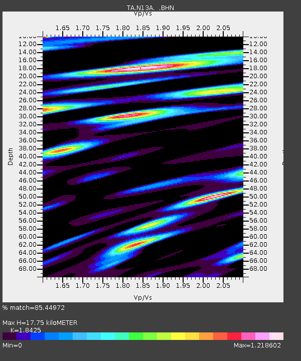
| Estimated Moho Depth: |
17.75 km |
| Estimated Crust Vp/Vs: |
1.84 |
| Assumed Crust Vp: |
6.276 km/s |
| Estimated Crust Vs: |
3.406 km/s |
| Estimated Crust Poisson's Ratio: |
0.29 |
|
| Radial Match: |
85.44972 % |
| Radial Bump: |
400 |
| Transverse Match: |
79.58985 % |
| Transverse Bump: |
400 |
| SOD ConfigId: |
2658 |
| Insert Time: |
2010-03-07 04:46:57.348 +0000 |
| GWidth: |
2.5 |
| Max Bumps: |
400 |
| Tol: |
0.001 |
|
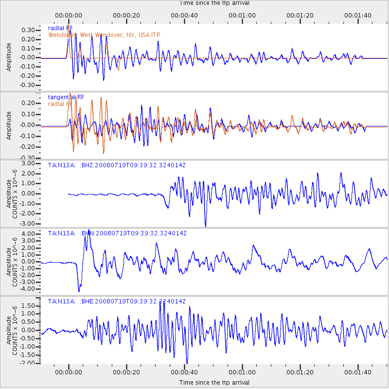
Signal To Noise
| Channel | StoN | STA | LTA |
| TA:N13A: :BHN:20080719T09:39:32.324014Z | 40.603104 | 1.7503361E-6 | 4.3108432E-8 |
| TA:N13A: :BHE:20080719T09:39:32.324014Z | 1.4876865 | 1.1832066E-7 | 7.953333E-8 |
| TA:N13A: :BHZ:20080719T09:39:32.324014Z | 10.312896 | 5.76271E-7 | 5.5878683E-8 |
| Arrivals |
| Ps | 2.4 SECOND |
| PpPs | 7.9 SECOND |
| PsPs/PpSs | 10 SECOND |


