You are here: Home > Network List > TA - USArray Transportable Network (new EarthScope stations) Stations List
> Station N13A Wendover, West Wendover, NV, USA > Earthquake Result Viewer
N13A Wendover, West Wendover, NV, USA - Earthquake Result Viewer
| Earthquake location: |
Northern Mid-Atlantic Ridge |
| Earthquake latitude/longitude: |
52.4/-31.8 |
| Earthquake time(UTC): |
2007/05/23 (143) 04:41:46 GMT |
| Earthquake Depth: |
10 km |
| Earthquake Magnitude: |
5.6 MS, 5.4 MB, 5.7 MW, 5.6 MW |
| Earthquake Catalog/Contributor: |
WHDF/NEIC |
|
| Network: |
TA USArray Transportable Network (new EarthScope stations) |
| Station: |
N13A Wendover, West Wendover, NV, USA |
| Lat/Lon: |
40.86 N/114.20 W |
| Elevation: |
1385 m |
|
| Distance: |
54.8 deg |
| Az: |
293.079 deg |
| Baz: |
48.067 deg |
| Ray Param: |
0.06521002 |
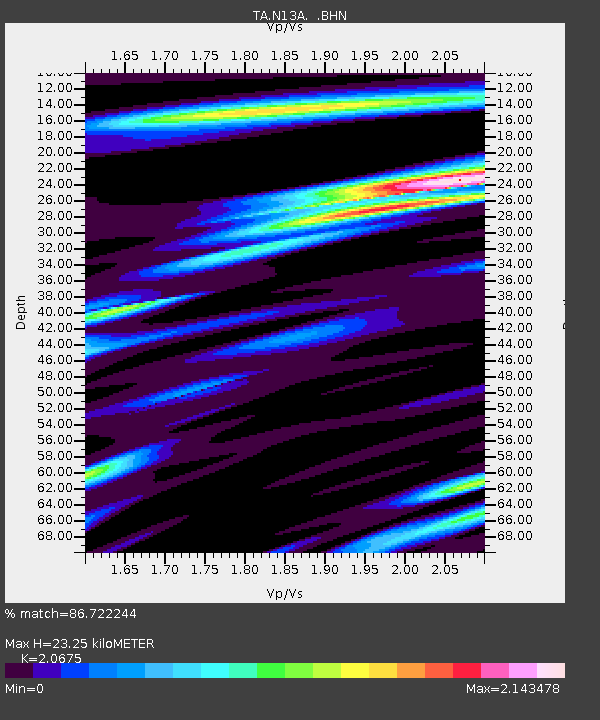
| Estimated Moho Depth: |
23.25 km |
| Estimated Crust Vp/Vs: |
2.07 |
| Assumed Crust Vp: |
6.276 km/s |
| Estimated Crust Vs: |
3.035 km/s |
| Estimated Crust Poisson's Ratio: |
0.35 |
|
| Radial Match: |
86.722244 % |
| Radial Bump: |
400 |
| Transverse Match: |
70.387794 % |
| Transverse Bump: |
400 |
| SOD ConfigId: |
2564 |
| Insert Time: |
2010-03-07 04:47:04.547 +0000 |
| GWidth: |
2.5 |
| Max Bumps: |
400 |
| Tol: |
0.001 |
|

Signal To Noise
| Channel | StoN | STA | LTA |
| TA:N13A: :BHN:20070523T04:50:45.55001Z | 2.2472138 | 2.1463467E-7 | 9.551146E-8 |
| TA:N13A: :BHE:20070523T04:50:45.55001Z | 3.2633893 | 3.3924542E-7 | 1.03954925E-7 |
| TA:N13A: :BHZ:20070523T04:50:45.55001Z | 5.7962546 | 4.0739067E-7 | 7.0285154E-8 |
| Arrivals |
| Ps | 4.1 SECOND |
| PpPs | 11 SECOND |
| PsPs/PpSs | 15 SECOND |


