You are here: Home > Network List > GM - US Geological Survey Networks Stations List
> Station IWM01 Jericho 2M Well Monitoring Station > Earthquake Result Viewer
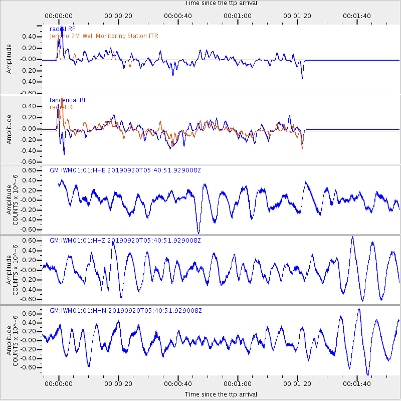
IWM01 Jericho 2M Well Monitoring Station - Earthquake Result Viewer
*The percent match for this event was below the threshold and hence no stack was calculated.
| Earthquake location: |
Tonga Islands Region |
| Earthquake latitude/longitude: |
-18.3/-172.1 |
| Earthquake time(UTC): |
2019/09/20 (263) 05:28:25 GMT |
| Earthquake Depth: |
10 km |
| Earthquake Magnitude: |
5.1 Mww |
| Earthquake Catalog/Contributor: |
NEIC PDE/us |
|
| Network: |
GM US Geological Survey Networks |
| Station: |
IWM01 Jericho 2M Well Monitoring Station |
| Lat/Lon: |
36.73 N/96.53 W |
| Elevation: |
328 m |
|
| Distance: |
89.7 deg |
| Az: |
51.085 deg |
| Baz: |
246.974 deg |
| Ray Param: |
$rayparam |
*The percent match for this event was below the threshold and hence was not used in the summary stack. |
|
| Radial Match: |
77.346275 % |
| Radial Bump: |
400 |
| Transverse Match: |
63.659393 % |
| Transverse Bump: |
400 |
| SOD ConfigId: |
19053131 |
| Insert Time: |
2019-10-11 12:42:08.821 +0000 |
| GWidth: |
2.5 |
| Max Bumps: |
400 |
| Tol: |
0.001 |
|
Signal To Noise
| Channel | StoN | STA | LTA |
| GM:IWM01:01:HHZ:20190920T05:40:51.929008Z | 0.84096634 | 2.0557465E-7 | 2.444505E-7 |
| GM:IWM01:01:HHN:20190920T05:40:51.929008Z | 1.4689322 | 2.5613417E-7 | 1.743676E-7 |
| GM:IWM01:01:HHE:20190920T05:40:51.929008Z | 1.22226 | 1.9395125E-7 | 1.5868247E-7 |
| Arrivals |
| Ps | |
| PpPs | |
| PsPs/PpSs | |


